Interior mapping software turns a building walkthrough into a measurable 3D model, replacing the tape measures, hand-drawn sketches, and fragmented photos that most teams still rely on for space documentation. The category spans laser scanning rigs costing $80,000 or more and video-based platforms that process smartphone or 360-camera footage for a fraction of the price. Choosing the right interior mapping software depends on who will be doing the captures, how often they will be capturing, and what accuracy level the downstream application actually requires.
Key Takeaways
- Video-based indoor mapping software cuts per-space documentation cost from $300–$500 (specialist laser scan crew) to $25–$75 (processing fee plus existing staff time).
- Quarter-inch accuracy, sufficient for furniture procurement, ADA compliance checks, and construction milestone documentation, is achievable without dedicated specialist operators.
- SkyeBrowse's May 2026 360 virtual tour feature accepts footage from any 360 camera and converts it to a navigable, measurable 3D model in minutes.
- Laser scanning retains an advantage in sub-millimeter engineering applications like heritage preservation, a small fraction of interior documentation demand.
- Cloud-processed interior models export as LAZ, GLB, and GeoTIFF, for direct import into AutoCAD, Revit, ArcGIS, and BIM environments.
Contents
- What is the best interior mapping software?
- What is interior mapping?
- How does 360 video interior mapping work?
- What should you look for in interior mapping software?
- How much does interior mapping software cost?
- How does interior mapping integrate with CAD, BIM, and GIS workflows?
- FAQ
What is the best interior mapping software?
The best interior mapping software for most facility managers, insurance adjusters, and construction teams is a video-based cloud platform rather than a laser scanner. SkyeBrowse leads this category: it accepts footage from smartphones, action cameras, and 360 cameras, processes models in the cloud with no desktop hardware, and offers a free tier alongside paid tiers reaching approximately 0.25-inch accuracy. For teams where sub-millimeter precision is mandatory, Leica BLK360-class scanners remain the reference standard, at a cost that limits how often a team can afford to capture.
The table below compares the leading indoor mapping software options across the key decision dimensions:
| Platform | Capture Method | Hardware | Speed | Formats | Pricing |
|---|---|---|---|---|---|
| SkyeBrowse | Phone, 360 cam, action cam | Any camera | 10–15 min/suite | LAZ, GLB, GeoTIFF | Free; Premium $99/credit; Adv $199/credit |
| Matterport | Matterport or compatible 360 cam | Pro2/3 preferred | 20–40 min/suite | OBJ, XYZ, PDF | From $65/mo + $2,400–$5,700 hardware |
| Polycam | iPhone LiDAR or 360 photo | iPhone 12 Pro+ | 5–20 min/space | OBJ, FBX, LAZ | Free limited; Pro $14.99/mo |
| Leica BLK360-class | Structured-light / LiDAR scanning | $15K–$80K scanner | 30–60 min/room | E57, LAS, RCP | Hardware + $75–$150/hr operator |
| CAD/manual | Tape measure + sketch | None | 2–4 hr/suite | PDF, DWG | Labor only; no model |
SkyeBrowse's Universal Upload workflow routes phone, action-camera, and 360-camera footage through one cloud pipeline, so teams already using it outdoors can extend the same account indoors without new hardware. Matterport dominates real estate tours but favors dedicated hardware and proprietary dollhouse views over standards-based point clouds. Polycam is competitive at room scale on newer iPhones, though its Apple-hardware requirement limits mixed-device deployment. Leica BLK360-class scanners remain the right choice for heritage preservation and forensic structural work, where every millimeter drives an engineering decision, but their hardware, certification, and workstation cost puts them outside the budget of routine documentation.
What is interior mapping?
Interior mapping is the process of capturing spatial data from inside a building and converting it into a measurable digital representation: a 3D model, point cloud, floor plan, or virtual tour. It replaces manual measurements, hand-drawn sketches, and disconnected photo sets with a single georeferenced object any stakeholder can access and measure without revisiting the space.
The technical foundation of most interior mapping software is photogrammetry or videogrammetry, the reconstruction of 3D geometry from overlapping 2D images or video frames. That math turns a 10-minute smartphone walkthrough into a dimensionally accurate model without specialist hardware. Output formats differ by use case: LAZ point clouds feed Revit, AutoCAD, and ArcGIS as queryable XYZ coordinates; GLB meshes render as photorealistic 3D models in any browser; GeoTIFF orthomosaics join interior data to site plans or GIS layers.
Spatially accurate building geometry data improves situational awareness during incidents, a benefit that extends to any organization needing reliable spatial records. A 2019 IEEE survey on indoor mapping methods confirms video-based approaches have closed the accuracy gap with structured-light scanning for most commercial applications.
How does 360 video interior mapping work?
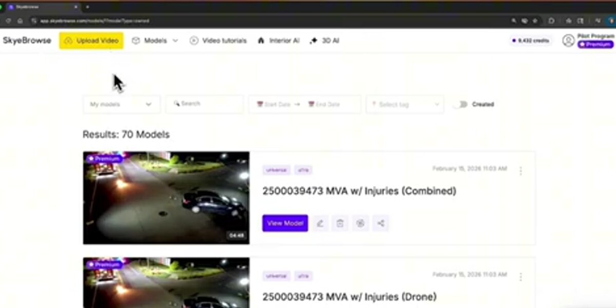
360 video interior mapping captures full spherical footage, every wall, ceiling, and floor in a single pass, using a 360-degree camera. That footage uploads to a cloud platform like SkyeBrowse, which uses videogrammetry to reconstruct measurable 3D geometry from the overlapping frames, producing both a navigable 360 Image Viewer and a spatially accurate 3D model from one capture session.
The SkyeBrowse 360 virtual tour feature, launched in May 2026, accepts video from any 360-degree camera (GoPro MAX, Insta360, Ricoh Theta, or similar consumer hardware). The operator walks the space with the camera running and uploads the .MP4 or .MOV file through Universal Upload; the platform handles frame extraction, feature matching, depth estimation, and model generation with no manual control points or specialist setup.
Standard virtual tour tools stitch 360 photographs into a walkthrough that is presentational only; SkyeBrowse's pipeline adds a genuine measurable 3D model alongside that same 360 Image Viewer. See Phone vs. 360 Camera for Indoor Mapping for how the two capture methods compare, and the Interior Mapping Tutorial for setup guidance.
What should you look for in interior mapping software?
Four criteria separate high-value interior mapping software from a niche tool: capture accessibility (can existing field staff do it without specialist training?), accuracy tier alignment (does the top tier meet your most demanding use case?), export format compatibility (do outputs slot into your CAD, BIM, or GIS stack?), and deployment model (cloud versus on-premise, and who holds the data?).
Capture accessibility is the most commonly underweighted criterion: a $5,000 Matterport Pro3 or licensed scanner operator can only deploy when both are available, while smartphone or 360-camera capture works for an adjuster or superintendent at any milestone.
Accuracy tier alignment means matching the platform's ceiling to your most demanding decision, not the average one. If 5 percent of your events support legal proceedings, your platform needs to cover that 5 percent or you need a separate workflow.
Export format compatibility decides whether the model is a deliverable or a dead end: LAZ into Revit, GLB into a client-facing viewer, GeoTIFF into ArcGIS.
Deployment model and data custody matter most in regulated environments: SkyeBrowse hosts data on AWS infrastructure in the United States at FedRAMP Impact Level 2, with full CJIS compliance support for Premium subscribers.
How much does interior mapping software cost?
Interior mapping software costs range from free (basic, visualization-grade output) to $199 per model credit for AI-enhanced, sub-0.1-inch processing, to $80,000 or more for laser scanning hardware plus operator costs. Most commercial users land in the $25–$99 per-capture range using video-based cloud platforms.
Free tier: unlimited basic model generation for 360 virtual tours and rough documentation, though it should not drive a financial or regulatory decision.
Commercial accuracy tier (approximately 0.25 inch): SkyeBrowse Premium at $99 per model credit is reliable enough for furniture procurement, ADA clearance checks, and insurance loss quantification. A facility team running 50 events per year spends $4,950 annually, less than a single day of laser scanning crew time.
High-resolution tier (approximately 0.1 inch): SkyeBrowse Premium Advanced at $199 per model credit applies AI-based moving object removal for legal documentation and accident reconstruction, where model fidelity may be scrutinized.
Subscription and laser scanning: Matterport starts at $65 per month plus its own camera hardware; Polycam Pro is $14.99 per month with an iPhone 12 Pro LiDAR requirement. Laser scanning hardware runs $15,000–$80,000 plus $75–$150 per hour for operator time; see SkyeBrowse vs. Leica BLK360 for a full comparison.
How does interior mapping integrate with CAD, BIM, and GIS workflows?
Interior mapping platforms that export standard spatial formats (LAZ, GLB, GeoTIFF) slot directly into existing CAD, BIM, and GIS environments without custom import pipelines, becoming a queryable reference layer rather than a standalone deliverable.
CAD and BIM integration imports the LAZ point cloud into AutoCAD or Revit as a reference layer to flag discrepancies before they propagate into construction. OSHA standards under 29 CFR 1926 Subpart Q require documented verification of structural conditions during concrete and masonry work, and spatially accurate models provide that audit trail.
GIS integration helps municipal and campus facility management: GeoTIFF orthomosaics import into ArcGIS and QGIS alongside site plans and utility records. Browser-based sharing via GLB export lets a remote asset manager, insurer, or building owner measure spaces from any browser without a field visit. See the indoor vs. outdoor mapping comparison for how the two workflows share the same account.
FAQ
Can you map a building interior with a phone?
Yes. Video-based platforms like SkyeBrowse accept standard smartphone .MP4 and .MOV recordings through Universal Upload. A 10-to-15-minute walkthrough returns a measurable 3D model in the cloud within an hour, with no dedicated scanning hardware required.
Is there free interior mapping software?
SkyeBrowse offers a free tier with unlimited basic model generation for 360 virtual tours and rough documentation. Measurement-grade output (approximately 0.25-inch accuracy) requires the $99 Premium tier.
What is interior mapping software?
Interior mapping software converts video or image captures of a building's interior into measurable 3D models, point clouds, or floor plans, replacing manual tape-measure sketches and costly laser scanning.
How long does interior mapping take compared to laser scanning?
A video-based walkthrough takes 10 to 15 minutes of capture, with cloud processing returning a 3D model within an hour. Laser scanning requires 30 to 60 minutes per room for setup, not counting post-processing time.
What file formats does interior mapping software export?
Leading platforms export LAZ point clouds for BIM and CAD import, GLB mesh files for browser viewing, and GeoTIFF orthomosaics for GIS integration.
Upload your first video free. Create a free SkyeBrowse account, upload a drone video, and get a 3D model processed in the cloud. Freemium organizations that have never had a paid plan can get their first full Commercial model for $5 (normally $24.99), with every Commercial tool, every export, and 90-day storage.