Photogrammetry, the science of deriving precise measurements and 3D models from overlapping photographs, has moved from surveying labs onto the devices in your pocket. Whether you need to scan an object with your phone, map a construction site by drone, or document a crash scene for court, there is a photogrammetry app built for that workflow. This guide compares the leading mobile and desktop photogrammetry apps for 2026 with pricing re-verified on each vendor's site in October 2026, clarifies what each category can and cannot do, and explains where capture apps end and cloud processing platforms begin.
The best photogrammetry app depends on your subject. For phone-based object and room scanning, Polycam, Scaniverse, and RealityScan lead in 2026 on iPhone, while KIRI Engine and RealityScan are the strongest picks on Android. For professional site-scale work, drone mapping, rooftops, accident scenes, construction sites, SkyeBrowse pairs a dedicated drone capture app with cloud processing to produce measurement-accurate 3D models from video. Pix4D and Agisoft Metashape remain the desktop standards for survey-grade output. Most mobile photogrammetry apps offer a free tier for evaluation: KIRI Engine keeps unlimited scans and exports free, and RealityScan is free for anyone under $1 million in annual revenue.
Key Takeaways
- Polycam no longer sells its Pro plan. Current plans are Free, Basic ($30/month or $150/year), Business ($400/year per user), and Enterprise ($1,200/year per user).
- Scaniverse's free plan covers mobile capture, metric scale, and exports with 20,000 monthly credits; Plus ($20/month) adds 360-camera support and Pro ($50/month) adds commercial rights.
- RealityScan from Epic Games is free for individuals and businesses under $1 million in annual revenue; larger organizations pay $1,250 per seat per year.
- KIRI Engine is the best photogrammetry app for Android: photo-based reconstruction, cloud processing, and unlimited free scans and exports.
- SkyeBrowse is the only platform in this roundup that provides both a dedicated drone capture app (SkyeBrowse Flight App) and a cloud processing engine in one workflow.
- For professional deliverables, point clouds, georeferenced orthomosaics, measurement-accurate meshes, a cloud or desktop processing platform is required regardless of which capture tool you use.
Contents
- What is a photogrammetry app and how does it work?
- Which mobile photogrammetry apps are worth using in 2026?
- Which photogrammetry app is best for each use case?
- What is the best photogrammetry app for iPhone and Android?
- What is the best photogrammetry app for Android?
- How do drone photogrammetry apps compare to mobile scanning?
- Which desktop and cloud processing platforms produce professional-grade outputs?
- How do the top photogrammetry apps compare on capture method and platform support?
- What do the free tiers actually include?
- What does each photogrammetry app cost in 2026?
- How did we evaluate these photogrammetry apps?
- FAQ
What is a photogrammetry app and how does it work?
A photogrammetry app uses overlapping images or video frames to reconstruct a three-dimensional model of a subject through a process called structure from motion (SfM). The app identifies common points across frames, triangulates their positions in space, and builds a dense point cloud that can be converted into a mesh or orthomosaic map. Modern mobile versions leverage phone hardware, LiDAR scanners on iPhone Pro models, depth cameras, and motion sensors, to speed up the reconstruction. Desktop and cloud platforms perform the same SfM computation but with greater processing power and higher output resolution.
Every app in this guide applies the same principles as aerial and close-range photogrammetry, just with a phone or drone camera as the sensor. The American Society for Photogrammetry and Remote Sensing (ASPRS) publishes the foundational accuracy standards that professional photogrammetric outputs are measured against. Those standards distinguish between map scales and positional accuracy classes, a reminder that "3D model" means different things depending on whether the output will be used for a social media post or as courtroom evidence.
On the mobile side, Apple ARKit (iOS) and Google ARCore (Android) provide the underlying sensor fusion frameworks most apps use to turn images into 3D models in real time. ARKit's LiDAR-based Scene Reconstruction API, available on iPhone Pro and iPad Pro, allows apps like Polycam and Scaniverse to generate mesh geometry in real time rather than waiting for post-processing. Android apps without LiDAR access, including KIRI Engine and RealityScan Mobile, instead reconstruct geometry from a sequence of standard photos, trading real-time preview for broader device compatibility.
For a broader look at software in this space, see our guide to photogrammetry software.
Which mobile photogrammetry apps are worth using in 2026?
Polycam, Scaniverse, and RealityScan lead the mobile 3D scanning app category in 2026. All three run on iOS and Android, support LiDAR-accelerated capture on compatible iPhones, and export industry-standard mesh formats. Polycam adds a drone photo mode for aerial captures, Scaniverse focuses on room-scale and object scanning with a free on-device tier, and RealityScan is Epic Games' free entry with no paid mobile tier at all. KIRI Engine and magicplan round out the category as strong Android-first and floor-plan-specific alternatives.
Polycam processes photos and LiDAR scans directly on-device for quick previews, then optionally sends data to its cloud for higher-quality meshing. Its drone mode accepts a folder of overlapping images from any camera-equipped drone, which makes it a lightweight option for pilots who already fly DJI or Autel hardware. Polycam streamlined its pricing in 2026: the Pro plan is gone, and the lineup is now Free, Basic ($30/month or $150/year), Business ($400/year per user), and Enterprise ($1,200/year per user, 3-user minimum), verified on poly.cam/pricing in October 2026.
Scaniverse, now under Niantic Spatial, runs on a credit model: the Free plan includes mobile capture, metric scale, FBX/SPZ/PLY exports, and 20,000 monthly credits (about 10 minutes of phone video). Plus ($20/month or $200/year) adds 360-degree camera support and more credits, and Pro ($50/month or $500/year) adds commercial usage rights, verified on nianticspatial.com/pricing in October 2026. It does not support drone photogrammetry workflows on its own; it is a handheld and BYOD (bring-your-own-data) capture tool that can ingest drone or 360-camera footage through its enterprise Capture product.
RealityScan, released by Epic Games, is free to download on iOS and Android, and the desktop application (formerly RealityCapture) shares the same license: free for individuals, students, educators, and businesses with under $1 million in revenue over the past 12 months, and $1,250 per seat per year above that threshold, verified on realityscan.com in October 2026. For most freelancers and small firms that makes it the strongest no-cost photogrammetry app pairing.
KIRI Engine targets Android users who need photogrammetry app Android capability without an iPhone Pro. It runs on standard camera images, uses cloud GPU processing, and its free Basic tier includes unlimited scans and unlimited exports at up to 150 photos (2 GB) per scan; the Pro tier ($17.99/month or $79.99/year) raises that to 500 photos (5 GB) and adds featureless object scanning, mesh-inclusive 3D Gaussian splats, PBR materials, quad mesh, and faster processing, verified on kiriengine.app/pricing in October 2026.
magicplan is a purpose-built floor-plan and interior-measurement app rather than a general object scanner. It runs on iOS and Android with the same feature set across every tier, no add-ons locked behind higher plans, starting with two free lifetime projects, then paid plans that bundle a set number of monthly project exports with a per-project overage fee (around $40 per additional project) once that allowance is used, verified on magicplan.app/pricing as of July 2026.

Which photogrammetry app is best for each use case?
The best photogrammetry app is the one built for your subject and output. Pick RealityScan or KIRI Engine for free object scanning, Scaniverse or Polycam for fast LiDAR room and object capture on iPhone, magicplan for floor plans, and SkyeBrowse when the subject is a site, roof, or scene that needs a drone and measurement-accurate 3D output.
| Use case | Best photogrammetry app | Why |
|---|---|---|
| Free object scanning | KIRI Engine, RealityScan | Unlimited free scans and exports (KIRI); free under $1M revenue (RealityScan) |
| iPhone LiDAR room or object scans | Scaniverse, Polycam | Real-time LiDAR meshing on iPhone Pro, quick previews |
| Android phone scanning | KIRI Engine | Photo-based reconstruction with cloud GPU processing, no LiDAR needed |
| Floor plans and interior measurements | magicplan | Purpose-built floor-plan exports (PDF, ESX, FML) |
| Survey-grade capture with RTK | Pix4Dcatch | AR guidance, RTK and auto-GCP on the Pro tier with hardware |
| Drone mapping of sites, roofs, crash and crime scenes | SkyeBrowse | Automated drone flight app plus cloud processing from video, 0.1 inch accuracy on Public Safety & Enterprise |
| Full desktop control over processing | Agisoft Metashape, Pix4D | Local processing with fine-grained parameters |
What is the best photogrammetry app for iPhone and Android?
On iPhone, Scaniverse, Polycam, and RealityScan are the best photogrammetry apps because they tap the LiDAR scanner on iPhone Pro models for fast, accurate object and room capture. On Android, KIRI Engine and RealityScan are the best choices since both run on standard camera photos with cloud-assisted processing and do not require Apple LiDAR. Most of these apps offer a free photogrammetry app tier, with paid plans adding high-resolution mesh and point-cloud exports. For drone-based capture on either platform, the SkyeBrowse Flight App (iOS and Android) automates the flight and feeds video straight into cloud processing.
iPhone photogrammetry benefits from dedicated hardware: the LiDAR scanner on iPhone Pro and iPad Pro models lets apps generate mesh geometry in real time rather than waiting on post-processing. That makes a mobile photogrammetry app on iPhone ideal for quick object, artifact, and interior scans. Android users without LiDAR rely on photo-based reconstruction, where KIRI Engine's cloud GPU pipeline and RealityScan Mobile's cross-platform engine close much of the gap. A free photogrammetry app tier on any of these tools is enough to evaluate quality before subscribing, though export formats and resolution stay capped on some until you upgrade, RealityScan being the notable exception with no paid mobile tier at all.
The shared ceiling for every handheld app is coverage area. Once a subject grows past room scale, a building facade, a roof, a stockpile, a crash scene, phone capture loses accuracy and a drone workflow becomes necessary. That is the boundary where a mobile scanning app hands off to a drone capture app paired with a cloud processing platform.
What is the best photogrammetry app for Android?
KIRI Engine is the best photogrammetry app for Android in 2026. It reconstructs from ordinary camera photos, processes in the cloud so a mid-range phone produces the same model as a flagship, and keeps unlimited scans and exports on the free tier. RealityScan is the best free alternative, and Polycam and Scaniverse also run on Android. For drone capture, the SkyeBrowse Flight App runs on Android phones and DJI smart controllers.
Android photogrammetry works differently from iPhone scanning because almost no Android phones ship a LiDAR sensor that apps can use. Android photogrammetry apps therefore rebuild geometry from overlapping photos or video frames, which takes longer than a live LiDAR mesh but often captures finer surface texture on small objects. Three habits matter more than the app: walk a full circle around the subject at two heights, keep 60 to 80 percent overlap between shots, and avoid shiny, transparent, or blank surfaces that give the reconstruction nothing to match.
- KIRI Engine: best overall Android photogrammetry app; up to 150 photos per scan free, 500 on Pro ($79.99/year).
- RealityScan: free guided AR capture for most users, with the same license as the desktop app.
- Polycam: cross-platform with a web viewer; free exports are lower resolution.
- Scaniverse: credit-based free plan with metric scale and PLY/SPZ exports.
- SkyeBrowse Flight App: automated drone video capture on supported DJI and Autel drones (Autel requires iOS), with Universal Upload for any MP4 or MOV from other drones or phones.
How do drone photogrammetry apps compare to mobile scanning?
Drone photogrammetry apps cover subjects that no handheld scanner can reach: large outdoor sites, rooftops, crash scenes, and agricultural fields. A drone captures hundreds of overlapping frames from altitude in minutes, the aerial photogrammetry approach, giving the processing engine enough coverage to produce georeferenced outputs at site scale. Mobile scanning apps are faster and require no pilot certification, but their coverage area tops out at roughly room scale before accuracy degrades significantly.
The capture side of a drone workflow typically involves a flight planning app that programs an autonomous mission and stores GPS-tagged video or photos. The SkyeBrowse Flight App is designed specifically for this role: it connects directly to supported DJI and Autel drones, automates the capture pattern, and packages the video file with embedded telemetry for immediate upload. Unlike generic flight apps that hand off raw files to a separate platform, the SkyeBrowse Flight App deposits data directly into the SkyeBrowse cloud for processing, closing the gap between capture and deliverable.
Pix4Dcatch takes a different approach on iOS: it turns a phone into a survey-grade capture device using AR guidance and LiDAR, with a free Discovery tier for basic scanning and GPS georeferencing. The Pro tier adds RTK connectivity and automatic ground control point detection, but it is typically sold bundled with hardware kits (from roughly $2,990 to $4,300 for a one-year professional license with cloud processing credits, verified via pix4d.com as of July 2026) or as an add-on to an existing Pix4D subscription, rather than as a standalone consumer purchase.
Where a generic drone mapping software pipeline requires pilots to manage separate flight, download, and processing steps, often across multiple applications, SkyeBrowse combines all three. The platform also supports video-based input (MP4, MOV) from drones already in the field, so teams do not need to re-fly previous missions.
For pilots exploring no-cost options before committing to a paid platform, our breakdown of free drone mapping software covers open-source alternatives in detail.
Which desktop and cloud processing platforms produce professional-grade outputs?
Pix4D, Agisoft Metashape, and SkyeBrowse are the three most widely used platforms for professional photogrammetric outputs in 2026. Pix4D and Agisoft require significant desktop computing power and technical configuration. SkyeBrowse offloads all processing to the cloud, so teams with a drone and a browser can generate measurement-accurate 3D models without managing local hardware or software licenses.
Pix4D dominates enterprise surveying and precision agriculture workflows. Pix4Dmapper runs on Windows and requires a high-RAM workstation for large datasets, listed from $333/month. PIX4Dreact for rapid response mapping is listed from $55/month, and PIX4Dmatic, the large-dataset photogrammetry engine, starts with the Analyst plan at $2,290 billed yearly (Standard $3,990 and Pro $4,990 per year), verified on pix4d.com/pricing in October 2026. Outputs, point clouds, DSMs, and orthomosaics, are survey-grade when supported by ground control points, but the subscription cost is significant and the learning curve is steep for non-survey professionals.
Agisoft Metashape (formerly PhotoScan) is the preferred tool in academic and forensic settings. It runs locally on Windows, macOS, and Linux, supports network processing across multiple workstations, and gives users fine-grained control over every processing parameter. Like Pix4D, it assumes the user will manage their own hardware and has no built-in capture app.
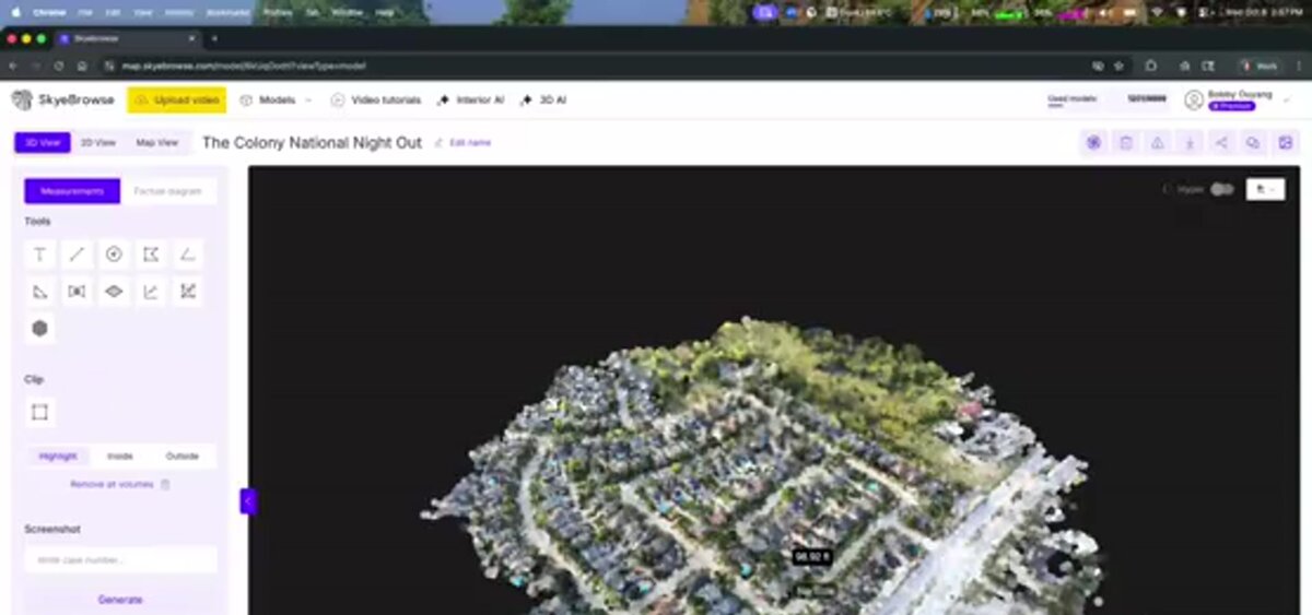
SkyeBrowse takes a different architectural approach: every computation happens on AWS GovCloud (US) at FedRAMP Impact Level 2, with full CJIS compliance maintained for Public Safety & Enterprise subscribers, so the only hardware requirement on the user side is a drone (or a phone for interior mapping) and a device with a browser. The platform accepts video uploads directly, an important distinction when field teams need to move quickly and cannot wait for a desktop workstation to batch-process images. Accuracy scales with the processing tier selected: Commercial and Pro reach 0.5 inch on 8K processing, and Public Safety & Enterprise reaches 0.1 inch on 16K processing with AI moving-object removal, so a team can match processing cost to how tight the deliverable's tolerance needs to be. Because videogrammetry accuracy scales with capture distance, flying closer or walking a phone next to the object of interest reaches survey-grade results without ground control points. In an independent accuracy study by AirBorne Works, SkyeBrowse video models came closest to Leica BLK360 laser-scan ground truth on 8 of 9 measurements, outperforming photo-based Pix4D Mapper and Leica BLK3D. Outputs include LAZ point clouds, GLB, OBJ and USDZ meshes, and GeoTIFF orthomosaics.
How do the top photogrammetry apps compare on capture method and platform support?
The table below separates each app's primary capture method from the platforms it runs on. LiDAR-capable apps get the fastest real-time previews on compatible iPhones; photo-based apps trade that speed for broader device compatibility, including every Android phone.
| App / Platform | Platforms | Primary Capture Method | Output Formats |
|---|---|---|---|
| Polycam | iOS, Android, Web, Vision Pro | Photos, LiDAR, drone photo sets | GLB, OBJ, USDZ, point cloud |
| Scaniverse | iOS, Android, Web | LiDAR, photos, gaussian splats | GLB, OBJ, point cloud, splat |
| RealityScan | iOS, Android | Photos, guided AR capture | 3D mesh, textured model |
| KIRI Engine | iOS, Android, Web | Photos (no LiDAR required) | OBJ, GLB, STL |
| magicplan | iOS, Android | Photos, 360 images, LiDAR (interior floor plans) | PDF, ESX, FML |
| Pix4Dcatch | iOS only | Photos, LiDAR, RTK (with hardware) | Feeds Pix4Dcloud, Pix4Dmatic |
| SkyeBrowse Flight App | iOS, Android | Drone video (MP4, MOV) | Feeds SkyeBrowse cloud |
| Pix4D (desktop) | Windows | Drone images | Point cloud, DSM, orthomosaic |
| Agisoft Metashape | Windows, macOS, Linux | Photos, video frames | Point cloud, mesh, orthomosaic |
| SkyeBrowse (cloud) | Web (all devices) | Drone or phone video (MP4, MOV) | LAZ, GLB, GeoTIFF |
Table verified as of July 2026 against each vendor's own site.
For a direct feature comparison between SkyeBrowse and Polycam, see SkyeBrowse vs Polycam.
What do the free tiers actually include?
Free tiers range from genuinely unlimited (KIRI Engine's Basic scans and exports, RealityScan under $1 million in revenue) to capped (Scaniverse's 20,000 monthly credits, Polycam's lower-quality exports, magicplan's two lifetime projects, SkyeBrowse's Freemium tier with unlimited uploads but no exports). Reading the fine print on export resolution and format matters more than the headline "free" label.
| App | Free Tier Limit |
|---|---|
| Polycam | Free tier available; low-resolution exports only, higher-quality meshing and formats require Basic or above |
| Scaniverse | Mobile capture, metric scale, FBX/SPZ/PLY exports, 20,000 monthly credits (about 10 minutes of phone video) |
| RealityScan | All features free for individuals and businesses under $1M annual revenue |
| KIRI Engine | Unlimited 3D scans and unlimited free exports, up to 150 photos (2 GB) per scan |
| magicplan | Two complimentary projects, lifetime (not monthly) |
| Pix4Dcatch | Discovery tier is free: basic LiDAR scanning and GPS georeferencing, no RTK or auto-GCP |
| SkyeBrowse | Freemium: unlimited uploads, 2 concurrent models, no exports; first full model $5 for eligible new organizations |
Polycam, Scaniverse, RealityScan and KIRI Engine re-verified October 2026; magicplan and Pix4Dcatch as of July 2026. Free-tier terms change frequently; confirm current limits on the vendor's site before choosing a workflow around them.
The pattern worth noting: apps backed by a larger platform business (RealityScan from Epic Games, Scaniverse under Niantic Spatial) keep core capture free and charge larger organizations or heavy cloud users, while apps monetizing export and processing infrastructure (Polycam, magicplan, SkyeBrowse) cap resolution, exports, or volume on the free tier and charge for scale.
What does each photogrammetry app cost in 2026?
Paid photogrammetry app pricing spans from KIRI Engine's $79.99/year Pro tier to PIX4Dmatic plans that start at $2,290 per year. Mobile apps built for object and room scanning cluster under $50/month; drone and desktop platforms built for site-scale deliverables either charge per finished model (SkyeBrowse from $24.99) or sell annual and perpetual licenses that cost far more.
| App / Platform | Paid Plan (October 2026) |
|---|---|
| Polycam | Basic $30/mo ($150/yr); Business $33/mo or $400/yr per user; Enterprise $1,200/yr per user |
| Scaniverse | Plus $20/mo ($200/yr); Pro $50/mo ($500/yr, commercial rights) |
| RealityScan | Free under $1M annual revenue; $1,250 per seat per year above it |
| KIRI Engine | Pro $17.99/mo or $79.99/yr ($6.66/mo equivalent) |
| magicplan | Plans from around $10/mo for a monthly project allotment; overages roughly $40/project |
| Pix4Dcatch | Pro bundled with hardware kits from approximately $2,990 to $4,300/yr, or added to a Pix4D subscription |
| SkyeBrowse | Freemium free; Commercial $24.99/model; Pro $49.99/model; Public Safety & Enterprise $199/model |
| Pix4D (desktop) | PIX4Dreact from $55/mo; PIX4Dmatic Analyst $2,290/yr; PIX4Dmapper from $333/mo |
| Agisoft Metashape | $179 Standard / $3,499 Professional (perpetual license) |
Re-verified on each vendor's pricing page in October 2026, except magicplan and Pix4Dcatch (July 2026).
The capture-vs-processing distinction matters when choosing tools. Polycam and Scaniverse are capture-and-preview tools that happen to produce exportable geometry. Pix4D and Agisoft are processing engines that assume organized image sets have already been collected. SkyeBrowse is designed around continuous-video input from a drone or phone, reducing the field workflow to: fly or walk, upload, receive deliverable.

How did we evaluate these photogrammetry apps?
Every entry in this guide was assessed on five published criteria: platform support, primary capture method, free-tier limits, export formats, and current pricing. Every figure was checked against the vendor's own pricing or product page in July 2026 and re-checked in October 2026, and SkyeBrowse's specifications come from its published plans and product documentation.
We did not run side-by-side accuracy benchmarks or process identical test datasets through every app; that kind of controlled test requires identical capture conditions and hardware across every platform, which this roundup does not claim to reproduce. Where a vendor publishes an accuracy specification (ASPRS positional accuracy classes, Apple's LiDAR resolution specs, SkyeBrowse's tiered accuracy figures), we cite that published number rather than an estimate. Platform support and pricing were confirmed from each vendor's official site rather than third-party aggregators, with the exception of figures explicitly marked otherwise. Because several vendors listed here (Polycam, Scaniverse, magicplan) have changed pricing more than once in the last year, we recommend confirming current numbers on the vendor's site before budgeting, and this guide is scheduled for quarterly re-verification.
FAQ
What is the best free photogrammetry app?
KIRI Engine's free Basic tier includes unlimited scans and unlimited exports, RealityScan is free for individuals and businesses under $1 million in annual revenue, and Scaniverse's free plan includes mobile capture, metric scale, and exports with 20,000 monthly credits. Polycam's free tier is limited to lower-quality exports. For drone photogrammetry, OpenDroneMap and WebODM offer free open-source processing, and SkyeBrowse offers a free Freemium tier so teams can evaluate drone-based 3D mapping before paying per model.
Can I use a photogrammetry app on my phone?
Yes. Mobile photogrammetry apps like Polycam, Scaniverse, RealityScan, and KIRI Engine use your phone's camera and depth sensors, Apple LiDAR on iPhone Pro models, or Google ARCore on Android, to capture and reconstruct 3D models. Results are best for small to medium objects in good lighting. Large outdoor sites require a drone and a dedicated processing platform like SkyeBrowse.
What is the difference between a photogrammetry capture app and a processing platform?
A capture app handles the image or video collection phase: flying a drone route, scanning an object, or walking a room. A processing platform ingests those assets and performs structure-from-motion computation to generate point clouds, meshes, and orthomosaics. Some tools only do one; SkyeBrowse covers both with its Flight App for automated drone capture and its cloud platform for processing and delivery.
What is the best photogrammetry app for iPhone and Android?
On iPhone, Scaniverse, Polycam, and RealityScan are the strongest photogrammetry apps because they use the LiDAR scanner on iPhone Pro models for fast, accurate scans. On Android, KIRI Engine and RealityScan are the best options since they work from standard camera photos and do not need Apple LiDAR. Most have a free tier; paid plans add higher-resolution exports. For drone capture on either platform, the SkyeBrowse Flight App automates the flight and sends video to cloud processing.
What is the best photogrammetry app for Android?
KIRI Engine is the best photogrammetry app for Android in 2026 because it reconstructs from ordinary camera photos, keeps unlimited scans and exports on its free tier, and processes in the cloud so phone hardware matters less. RealityScan is the strongest free alternative, and Polycam and Scaniverse also run on Android. For drone capture from an Android phone or controller, the SkyeBrowse Flight App automates the flight and uploads video for cloud processing.
Is RealityScan free?
Yes for most users. Epic Games licenses RealityScan free to individuals, students, educators, and businesses with under $1 million in revenue over the past 12 months. Organizations above that threshold buy seats at $1,250 per seat per year, which includes all features and a year of updates.
Is Polycam's Pro plan still available in 2026?
No. Polycam no longer offers the Pro plan to new signups. Its plans are Free, Basic ($30/month or $150/year), Business ($33/month or $400/year per user), and Enterprise ($1,200/year per user, 3-user minimum). Existing Pro subscribers keep their legacy pricing while the subscription stays active.
Upload your first video free. Create a free SkyeBrowse account, upload a drone video, and get a 3D model processed in the cloud. Freemium organizations that have never had a paid plan can get their first full model for $5 (normally $24.99), with every Pro tool and export included and 90-day storage.