Drone mapping software turns aerial video or photographs into georeferenced 2D maps and 3D models that teams can measure, annotate, share, and export. The best choice depends on the capture method, the output your team must deliver, the field-to-model turnaround, and whether the workflow runs in a browser, on a local workstation, or across both.
This guide compares SkyeBrowse, DroneDeploy, Pix4D, DJI Terra, WebODM and ODM, Propeller, UgCS, and GeoNadir. It separates flight planning from data processing, records vendor pricing checked in July 2026, and gives shortlists for public safety, construction, and survey work.
Key Takeaways
- SkyeBrowse is the first platform to test when the field workflow starts with continuous drone video and a model is needed while the team is still on site.
- DroneDeploy, Pix4D, DJI Terra, WebODM, Propeller, and GeoNadir center on still-image or geospatial-data workflows, while UgCS primarily handles flight planning and control.
- Public safety buyers should compare video capture, processing time, exports, model security, and chain-of-custody requirements together.
- Construction buyers should prioritize repeatable site capture, volume and elevation analysis, design overlays, collaboration, and a pricing model that matches flight frequency.
- Survey buyers should verify the required coordinate system, GCP or RTK workflow, quality report, export format, and the professional responsible for the final deliverable.
Contents
- What is drone mapping software?
- How do capture methods and flight-planning categories differ?
- How did we evaluate these drone mapping platforms?
- Which drone mapping software platforms are worth evaluating?
- How do the platforms compare by capture method and platform?
- What does drone mapping software cost as of July 2026?
- Which platform fits public safety, construction, or survey work?
- What should you test before choosing a platform?
- What are the practical limits of drone mapping software?
- Related Guides
- FAQ
- When was this guide updated?
What is drone mapping software?
Drone mapping software processes aerial video or still images from an unmanned aircraft system into outputs such as orthomosaics, point clouds, textured meshes, digital surface models, and elevation products. Photogrammetry uses overlapping photographs, while videogrammetry uses frames from continuous video. The software also manages georeferencing, measurement, annotation, export, and sharing.
For the complete capture and processing explanation, use the drone mapping guide. The 3D drone mapping guide goes deeper into site-scale point clouds, meshes, and orthomosaic outputs. This page stays focused on choosing the software layer.
The main buying question is whether the tool matches the data you already collect. A photo-processing platform expects a set of overlapping images, camera metadata, and often a planned grid. A video-first platform expects a continuous file and a capture path with enough overlap. A flight-planning platform may produce a route and control a drone while leaving reconstruction to another product.
How do capture methods and flight-planning categories differ?
Photo-based mapping builds geometry from overlapping still images, video-first mapping extracts frames from continuous footage, and LiDAR workflows process laser range measurements. Flight-planning software designs the mission and controls the aircraft. These categories can appear in one vendor portfolio, yet they remain separate buying decisions.
Photogrammetry is the familiar grid-flight workflow. The pilot captures overlapping photographs, then the software aligns the images and produces a dense reconstruction. It fits planned missions, GCPs, RTK workflows, and survey deliverables that depend on image metadata. Pix4D, DJI Terra, WebODM and ODM, DroneDeploy, Propeller, and GeoNadir publish related workflows.
Videogrammetry uses frames from a continuous video file. SkyeBrowse accepts .MP4 and .MOV through Universal Upload, plus other supported sources, and creates a 3D model and 2D map in the cloud. DJI .SRT or Autel .ASS telemetry can accompany the video for georeferencing. This suits teams that value a quick capture path from a drone, phone, action camera, 360 camera, or body-worn camera.
LiDAR workflows start with point clouds captured by a laser sensor. DJI Terra processes compatible DJI LiDAR data, and Propeller processes or accepts pre-processed LiDAR data. Assess the complete capture stack rather than software price alone.
UgCS belongs in the flight-planning category. The vendor describes desktop mission planning and flight control with terrain following, corridor missions, vertical scans, LiDAR tools, offline operation, and enterprise fleet features. Reconstruction normally takes place in a separate processor, while SPH Engineering also offers UgCS Mapper. Treat UgCS as a planning and control choice in the procurement matrix.
How did we evaluate these drone mapping platforms?
This comparison uses processing approach, capture and platform support, processing location, vendor turnaround language, accuracy and georeferencing controls, free-plan limits, exports, security, and pricing. Sources are vendor product and pricing pages, official documentation, published specifications, and the SkyeBrowse knowledge base.
The ranking order is an editorial fit order, with SkyeBrowse first because this page's primary reader is choosing drone mapping software for field use. It does not claim that one platform wins every capture method or professional standard. The tables distinguish documented capability from a recommendation for a specific team.
I checked the vendor pages on July 14, 2026. DroneDeploy, Pix4D, DJI, WebODM and ODM, Propeller, UgCS, and GeoNadir supplied the third-party product and price references. SkyeBrowse facts come from the local KB. No third-party benchmark or hands-on result is invented here.
The accuracy column needs care. Relative model measurement, absolute georeferencing, GCP or RTK control, and a certified survey deliverable answer different questions. Read a vendor's test conditions and deliverable definition; where no figure is published, verify it in the pilot.
Which drone mapping software platforms are worth evaluating?
The seven platforms and one open-source ecosystem cover video-first cloud mapping, construction capture, photo-based photogrammetry, DJI-centered reconstruction, self-hosted processing, earthwork mapping, flight planning, and environmental analysis. Each review states where the product fits and what to verify.
1. SkyeBrowse: video-first mapping for field documentation
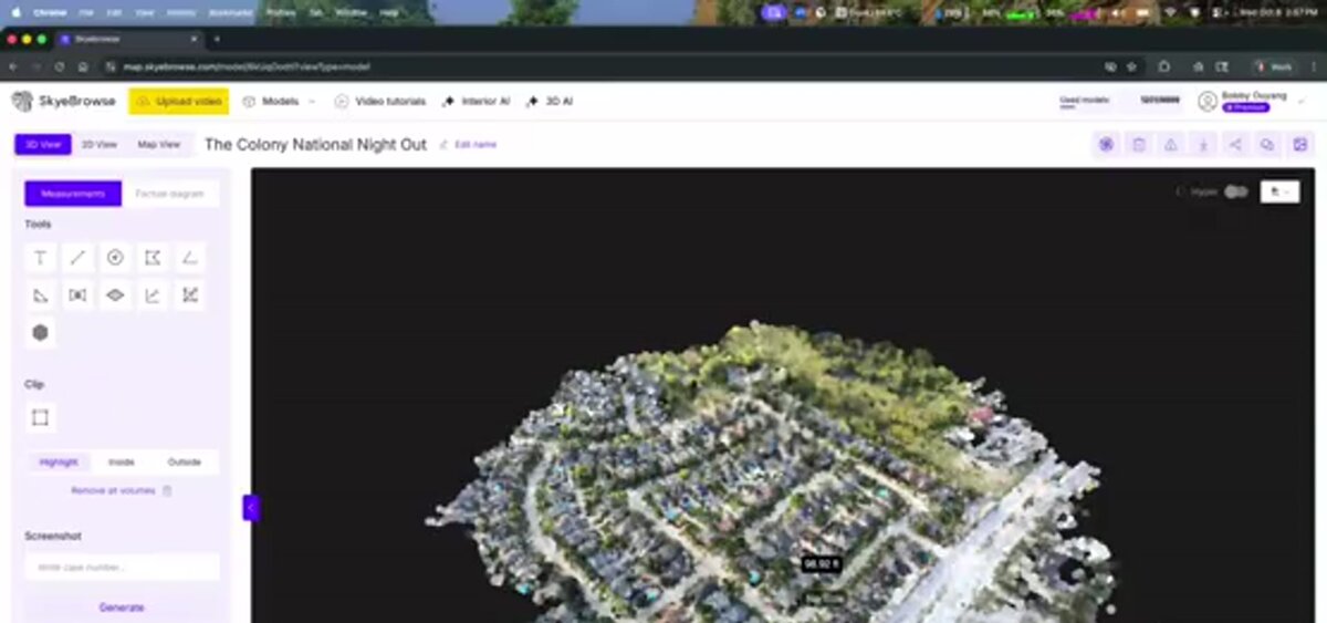
SkyeBrowse is a cloud-based videogrammetry platform that processes continuous video into 3D models and 2D maps. The Flight App automates capture for supported drones and controllers. Universal Upload accepts documented video sources from manual drone flights, phones, action cameras, 360 cameras, and body-worn cameras. The workflow runs at app.skyebrowse.com without a desktop reconstruction application.
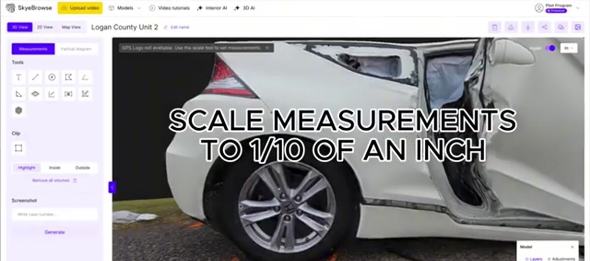
The KB states that processing runs at about one minute per minute of video and that most models are ready in under 5 to 10 minutes after upload, subject to source and connection conditions. Freemium processes at basic resolution; Commercial and Pro models are 8K at approximately 0.5 inch; Public Safety & Enterprise is approximately 0.1 inch. Exports (LAZ, GLB, OBJ, USDZ, GeoTIFF) come with Pro and Public Safety & Enterprise models.
Best fit: public safety, insurance, construction, and other teams that need a model from video during the same field operation.
Fit note: SkyeBrowse is video-only for 3D model generation. Teams built around large still-photo sets, local processing, or a specific GCP quality-report workflow should include photo tools in the pilot. The choice depends on the deliverable and capture method.
2. DroneDeploy: cloud site documentation and construction workflows
DroneDeploy positions its platform around aerial and ground reality capture. Its current pages describe drone imagery, 360 cameras, fixed cameras, robots, and smartphones across Unified, Aerial, Aerial Pro, and Ground offerings. Aerial Pro lists GCP tagging, accuracy alerts, expert map review, cut and fill, and progress-to-design analysis. Aerial lists orthomosaics, 3D models, panos, issue tagging, and Esri, Autodesk, and Procore integrations.
Best fit: construction and infrastructure teams mapping the same sites repeatedly, especially when site collaboration, design overlays, or earthwork quantities are central.
Fit note: the pricing page uses custom quotes for Aerial and Unified, with a 14-day trial and a separately listed individual Flight and Analysis plan. Ask sales to map pilots, sites, images, exports, and integrations before comparing it with per-model or self-hosted pricing.
3. Pix4D: a product family for photo mapping and rapid response
Pix4D publishes a broad product family. PIX4Dmapper is the classic desktop workflow for drone images, PIX4Dmatic handles large-area photogrammetry, PIX4Dcloud supplies online processing and collaboration, PIX4Dreact focuses on rapid 2D maps, and PIX4Dfields targets agriculture.
Best fit: teams that want a mature photo-based workflow with product choices for surveying, cloud collaboration, agriculture, or rapid incident maps.
Fit note: Pix4D pricing varies by product. Name the exact product, then verify cloud credits, desktop processing, exports, and support. PIX4Dmapper and PIX4Dcloud are separate line items.
4. DJI Terra: DJI-centered local reconstruction
DJI Terra processes visible-light imagery, DJI LiDAR data, and supported multispectral imagery into 2D and 3D products. DJI's FAQ documents Windows-only operation, 32 GB RAM, a 4 GB NVIDIA GPU minimum, and Agriculture, Standard, Flagship, and cluster licenses. Other variants depend on region, license type, and dealer channel.
Best fit: DJI fleets that prefer a local Windows workflow closely tied to DJI aircraft and payloads.
Fit note: include hardware, operating system, license binding, and GPU requirements in the purchase decision. Mixed-drone organizations should confirm how non-DJI imagery will be handled.
5. WebODM and ODM: open-source local processing
WebODM is a free and open-source interface for generating maps, point clouds, elevation models, and textured 3D models from aerial images on a local computer. ODM is a command-line toolkit in the OpenDroneMap ecosystem. The current WebODM site says the projects have decoupled, so check current documentation before installing.
ODM documents JPEG and TIFF inputs, GCP support, orthorectified imagery, surface and terrain models, textured 3D models, and classified point clouds. WebODM and ODM fit teams that can provide local hardware, installation, updates, and troubleshooting.
Best fit: technically capable teams that want local or self-hosted processing and can own the operational work around it.
Fit note: free software still has infrastructure costs. Budget for a workstation or server, storage, GPU configuration, operator time, upgrades, and output validation.
6. Propeller: construction and earthwork mapping
Propeller is a cloud worksite platform for construction, aggregates, mining, and waste management. Its documentation lists photogrammetry and LiDAR processing, pre-processed data imports, orthophotos, terrain, point clouds, designs, contours, measurements, and exports such as GeoTIFF, LAZ, DXF, GeoJSON, and CSV. Propeller also lists a 14-day trial and an annual platform with Bring Your Own Data credits.
Best fit: civil construction and earthwork teams that need recurring site maps, cut and fill, machine or design context, and shared quantities.
Fit note: Propeller's price uses an annual platform and processing credits. Ask how included credits, upload size, storage, additional packs, GCP workflow, and site count apply to the expected flight schedule.
7. UgCS: flight planning and control for demanding missions
UgCS is desktop mission-planning and flight-control software for professional UAV operations. Published capabilities include terrain following, custom DEM or DSM import, corridor inspections, vertical flight planning, offline maps, LiDAR tools, and multi-drone features. Its shop lists Pro, Expert, and Enterprise licenses.
Best fit: survey, infrastructure, LiDAR, geophysics, and research teams that need detailed route design or fleet control before processing data in another tool.
Fit note: UgCS is a flight-planning choice. Confirm the drone, controller, sensor, route export, and downstream processor before treating its license as the total mapping budget.
8. GeoNadir: environmental mapping and analysis
GeoNadir combines drone data management, processing, analysis, and collaboration for environmental teams. Its current plans list RGB orthomosaics and elevation models in Essentials, with larger datasets, thermal processing, advanced analysis, NDVI and spectral indices, downloads, and more projects in Professional. Pro+ supports tailored limits.
Best fit: environmental consultants, mining rehabilitation teams, government teams, rangers, and drone analysts who need spatial analysis around monitoring and compliance.
Fit note: GeoNadir fits environmental change, vegetation, and monitoring analysis. It follows a different buying path from a rapid public-safety scene model or local desktop reconstruction.

How do the platforms compare by capture method and platform?
The matrix below separates what the operator captures from where processing and review happen. The distinction makes the shortlist clearer: SkyeBrowse starts with video and a browser, Pix4D and DJI Terra center on photo or sensor data, WebODM and ODM run locally, Propeller and GeoNadir use cloud workspaces, and UgCS primarily plans and controls the flight.
| Platform | Category and capture method | Processing and review platform | Outputs or workflow emphasis |
|---|---|---|---|
| SkyeBrowse | Video-first videogrammetry from supported drone video, manual drone video, phone, action camera, 360 video, or body-worn camera | Cloud web app at app.skyebrowse.com | 3D model, point cloud, 2D map, measurements, annotations, sharing, and plan-dependent exports |
| DroneDeploy | Aerial imagery plus current ground, 360, fixed-camera, robot, and smartphone capture paths | Cloud reality-capture platform with mobile capture | Orthomosaics, 3D models, panos, inspections, progress, design overlays, and earthwork analysis |
| Pix4D | Overlapping drone or ground photos; product-specific cloud, desktop, and rapid-response workflows | PIX4Dmapper and PIX4Dmatic desktop; PIX4Dcloud and PIX4Dreact cloud or field workflows | Orthomosaics, point clouds, 3D models, maps, reports, and product-specific exports |
| DJI Terra | DJI visible-light photos, supported DJI LiDAR, and supported multispectral imagery | Windows desktop with local reconstruction and license binding | 2D maps, 3D models, point clouds, true digital orthophoto maps, DSMs, and DJI payload workflows |
| WebODM and ODM | Geotagged JPEG or TIFF still images, with GCP support | Local computer, Docker, or self-hosted deployment | Orthophotos, DSMs, DTMs, textured models, classified point clouds, and open exports |
| Propeller | Photogrammetry, LiDAR, and pre-processed survey data | Cloud worksite platform | Orthophotos, terrain, point clouds, contours, volumes, designs, and construction collaboration |
| UgCS | Mission planning for photogrammetry, LiDAR, corridor, vertical, and multi-drone operations | Desktop planner and flight-control connections; downstream processing is separate | Routes, terrain-aware missions, sensor planning, offline operation, and fleet control |
| GeoNadir | Geotagged drone imagery for RGB, thermal, and environmental analysis workflows | Cloud workspace with processing, analysis, and sharing | Orthomosaics, elevation models, volumes, change detection, spectral analysis, vectors, and reports |
It's a category map rather than a quality score. A cloud label does not answer whether exports, retention, access control, integrations, or workstation capacity match the buyer's policy. Those questions belong in the pilot.
What does drone mapping software cost as of July 2026?
Pricing ranges from free open-source software to annual enterprise agreements. Compare the unit of purchase: model credit, subscription, desktop license, platform plus processing credits, or quote based on sites and users. The table records public vendor figures available on July 14, 2026.
Pricing snapshot, as of July 2026. Check the linked vendor page before purchase because plans, regional taxes, credits, and hardware requirements can change.
| Platform | Public entry or trial | Published paid price | Pricing unit and caveat |
|---|---|---|---|
| SkyeBrowse | Freemium is free (basic resolution, 2 GB uploads); one-time $5 first Commercial model offer for Freemium organizations that have never had a paid plan | Commercial $24.99 per model; Pro $49.99 per model ($39.99 billed annually); Public Safety & Enterprise $199 per model per year | Per completed model, not per seat; Commercial includes up to 5 users, Public Safety & Enterprise unlimited users |
| DroneDeploy | 14-day trial | Flight and Analysis plan listed at $4,188 billed annually; Ag Lite at $1,908 billed annually | Aerial, Aerial Pro, Ground, and Unified use custom quotes; annual and monthly options vary by plan |
| Pix4D | 15-day trial | PIX4Dmapper starts at $333/month; PIX4Dcloud Starter is listed from $107.50/month on annual billing | Product-specific subscription; cloud credits and desktop processing differ by product |
| DJI Terra | Version and trial availability vary by license path | Agriculture online license listed at $300 for 1 year and 3 devices | Standard, Flagship, perpetual, cluster, and regional dealer options have separate terms |
| WebODM and ODM | WebODM and ODM are free and open source | OpenDroneMap installer lists $64 Standard or $149 Business as one-time purchases | Those paid installer prices cover installation support and updates, not a recurring WebODM software subscription |
| Propeller | 14-day trial | Platform pricing is quote-based; vendor documentation describes an annual platform with included BYOD credits | Processing packs, storage, users, sites, and data services affect total cost |
| UgCS | UgCS Open is free | Pro $109/month, Expert $189/month, Enterprise $279/month; perpetual licenses start at $1,090 | Flight-planning software; processing and hardware are separate budget lines |
| GeoNadir | Essentials is free forever | Professional $84/month; Pro+ is quote-based | Monthly page lists annual billing savings and different dataset, storage, user, and analysis limits |
The same price can mean different operational capacity. A per-model plan can fit occasional final models and many users. A site platform can fit weekly mapping with design or earthwork context. A free local tool can fit a technical team with spare compute and staff time. Compare one year of hardware, storage, processing, exports, support, and review.
Which platform fits public safety, construction, or survey work?
Public safety usually starts with fast documentation, evidence controls, and flexible capture. Construction usually starts with repeatable site coverage, quantities, collaboration, and design context. Survey work usually starts with coordinate systems, GCP or RTK procedures, quality reporting, and the professional standard for the final deliverable.
| Use case | Selection checklist | Platforms to put on the first shortlist | Questions to resolve in a pilot |
|---|---|---|---|
| Public safety | Video or photo capture from the available fleet, rapid model access, measurements, annotations, exports, access logs, storage, and Public Safety & Enterprise CJIS or chain-of-custody requirements where applicable | SkyeBrowse first for video-first documentation; Pix4D for photo or rapid 2D workflows; WebODM or ODM for self-managed processing | Can the team capture and upload under incident conditions? Which plan provides the required security and exports? How will the agency retain the source file, model, and activity record? |
| Construction | Repeatable coverage, orthomosaics, 3D surfaces, volumes, design overlays, collaboration, integrations, and predictable cost for recurring flights | DroneDeploy, Propeller, Pix4D, DJI Terra, and SkyeBrowse for periodic video-based site snapshots | What is the cost per site or model at the expected flight frequency? Are cut and fill, design comparison, storage, and exports included? Can the field team repeat the capture path? |
| Survey | GCP or RTK workflow, coordinate reference system, checkpoints, quality report, point-cloud and raster exports, traceable processing settings, and a licensed professional review path | Pix4D, DJI Terra, Propeller, WebODM or ODM, and SkyeBrowse when its documented video workflow fits the deliverable | Does the vendor's published accuracy describe relative measurement or absolute position? What source control is required? Which professional signs off on the final survey product? |
Public safety: start with the evidence workflow
Public safety teams often need to document a changing scene before it is cleared. SkyeBrowse's video-first workflow can reduce capture burden when an agency needs a 3D model from a supported drone or manual video source. Public Safety & Enterprise includes full CJIS compliance and chain-of-custody controls, while Commercial and Pro have a different retention profile. The purchasing question is the policy requirement.
Pix4D offers photo-based mapping and a rapid 2D response product. WebODM or ODM can serve agencies with a local infrastructure policy and technical operator. Use the agency's evidence-retention procedure, metadata requirements, export path, and review process in the pilot.
Construction: prioritize repeatability and quantities
Construction software earns its place when a team can capture repeatedly and turn the result into a decision. DroneDeploy and Propeller emphasize site documentation, progress, design context, and earthwork. Pix4D and DJI Terra provide photo reconstruction, while SkyeBrowse fits periodic video captures when its export and accuracy tiers match the deliverable.
Test one site across the intended flight interval. Record operator time, processing completion, measurement, design comparison, export, and review access. A repeatable process is stronger evidence than one attractive model.
Survey: define the deliverable before choosing the processor
Survey buyers should write the final deliverable first. A georeferenced orthomosaic, surface model, point cloud, and signed boundary survey have different requirements. GCPs, RTK or PPK, checkpoints, coordinate systems, camera calibration, and quality reports may matter more than the interface.
Pix4D, DJI Terra, Propeller, and WebODM or ODM publish workflows around still imagery, terrain, GCPs, or sensor data. SkyeBrowse documents survey-grade relative and absolute accuracy for Commercial, Pro, and Public Safety & Enterprise models and can use drone telemetry for georeferencing. In an independent accuracy study by AirBorne Works, SkyeBrowse video models came closest to Leica BLK360 laser-scan ground truth on 8 of 9 measurements, outperforming photo-based Pix4D Mapper and Leica BLK3D. Confirm the professional standard, control procedure, and sign-off path.
What should you test before choosing a platform?
Run a small pilot using the same source, capture path, coordinate system, and deliverable that the team will use in production. Compare capture to export, then repeat with a second operator. Test upload recovery, retention, export handling, and measurement verification.
Use this checklist:
- Capture: Can the pilot collect the required overlap, angles, altitude, and telemetry with the available aircraft and controller?
- Ingest: Does the system accept source files, metadata, telemetry, GCPs, and coordinate systems without unsupported manual conversion?
- Processing: What does the vendor publish about processing time, queue priority, dataset limits, and failed jobs? Record observed time without presenting it as a universal benchmark.
- Review: Can the intended users navigate, measure, annotate, compare, and share the model on the devices they carry?
- Exports: Open the exact LAZ, GeoTIFF, GLB, OBJ, DXF, or report in the next system. Confirm units, coordinate reference, scale, and metadata.
- Accuracy: Use known scene references, checkpoints, GCPs, RTK or PPK where the workflow requires them. Separate relative measurements from absolute positions.
- Operations: Confirm roles, retention, security, support, account recovery, and post-trial data handling.
- Cost: Project annual usage using credits, subscriptions, storage, workstation time, hardware, support, and training.
What are the practical limits of drone mapping software?
Every approach needs suitable capture geometry, overlap, lighting, texture, and position information. Water, glass, mirrors, featureless surfaces, dense vegetation, moving objects, excessive sky, and uneven motion can reduce reconstruction quality. A software choice cannot remove the need for safe flight operations, good capture practice, and a deliverable-specific accuracy check.
Commercial drone operations in the United States still require applicable FAA rules and pilot qualifications. Software does not replace airspace review, visual-line-of-sight procedures, site permissions, or the operator's responsibility for the flight. Use the FAA UAS resources before planning a mission.
The coordinate question also deserves a written answer. A model can contain useful relative measurements while its absolute position needs telemetry, GCPs, RTK or PPK, checkpoints, or a different capture procedure. Ask how a published figure was measured and whether it describes scale, relative accuracy, or georeferenced coordinates. The ASPRS positional accuracy standards provide a reference point.
Indoor or mixed scenes need their own capture method. GPS may be unavailable, lighting may change, and smooth or reflective surfaces can reduce visible features. SkyeBrowse supports interior mapping from video through a plan-dependent workflow, while the sibling UAV mapping software guide covers enterprise procurement.
Related Guides
- Drone mapping guide: the educational pillar on how drone mapping works, capture methods, accuracy, and cost.
- UAV mapping software: the enterprise and government procurement angle on UAV mapping platforms.
- 3D drone mapping: the site-scale 3D workflow, covering point clouds, meshes, and orthomosaic outputs.
- 3D mapping software: a ranked comparison across drone, indoor, and mobile capture methods.
FAQ
What is the best drone mapping software?
There is no single fit for every capture path. Start with SkyeBrowse for video-first field documentation, DroneDeploy or Propeller for recurring construction sites, Pix4D or DJI Terra for photo-based reconstruction, WebODM or ODM for local open-source processing, UgCS for flight planning, and GeoNadir for environmental analysis.
Is there free drone mapping software?
Yes. SkyeBrowse has a Freemium tier, WebODM and ODM are free and open source, and GeoNadir has a free Essentials plan. Compare exports, dataset limits, hosting, support, and the hardware or operator time required to make a free option useful.
What is the difference between drone mapping software and photogrammetry software?
Drone mapping software is usually a drone-oriented workflow that may include capture guidance, flight planning, processing, measurements, or sharing. Photogrammetry software describes the reconstruction method and may accept drone, ground, or other photographs. UgCS illustrates the distinction from another angle because its primary role is flight planning and control.
When was this guide updated?
This guide was updated on July 14, 2026. Pricing and product details were checked against the linked vendor pages on that date, and SkyeBrowse product facts were checked against the local knowledge base.
Upload your first video free. Create a free SkyeBrowse account, upload a drone video, and get a 3D model processed in the cloud. Freemium organizations that have never had a paid plan can get their first full Commercial model for $5 (normally $24.99), with every Pro tool and export included and 90-day storage.