Avata 360 3D Model
Introduction
Mapping with an Avata 360 takes the right techniques and settings, and with them you can create accurate and detailed 3D models. In this tutorial, we'll set you up for success with the best practices for Avata 360 mapping indoors and outdoors, from capture settings to the upload that turns your 360 flight into a measurable SkyeBrowse 3D model.
Note: SkyeBrowse works with all 360 cameras, but this tutorial will focus on the Avata 360.
Key Takeaways
- SkyeBrowse builds the 3D model from your Avata 360 video itself, with no photo grid to plan.
- Upload the native .OSV file for speed, or a 360 MP4 exported through DJI Studio for a higher quality model, both through Universal Upload.
- Avata 360 firmware v01.00.0800 (DJI release notes, October 20, 2026) added Waypoint Flight, which helps you repeat a mapping route on later visits.
- Fly slowly in one continuous video: about 1 mph indoors and 5 to 10 mph outdoors.
- Uploading is free on Freemium, and eligible free accounts can get their first full Commercial model for $5.
Contents
- Can you do photogrammetry with the DJI Avata 360?
- Before You Start
- The Easy Way: Upload OSV File into SkyeBrowse
- The Advanced Way: Export Avata 360 Video on PC/Mac with DJI Studio
- How do you upload Avata 360 video to SkyeBrowse?
- What capture settings work best for an Avata 360 3D model?
- Does the DJI Avata 360 support waypoints, and should you use them for mapping?
- How much does it cost to turn Avata 360 video into a 3D model?
- FAQ
Can you do photogrammetry with the DJI Avata 360?
Yes. SkyeBrowse builds the 3D model from the Avata 360 video itself, a method called videogrammetry, so you don't need a photo grid or a mapping app. The SkyeBrowse Flight App doesn't support the Avata, so you fly it manually and upload the native .OSV file or a 360 MP4 exported from DJI Studio through Universal Upload.
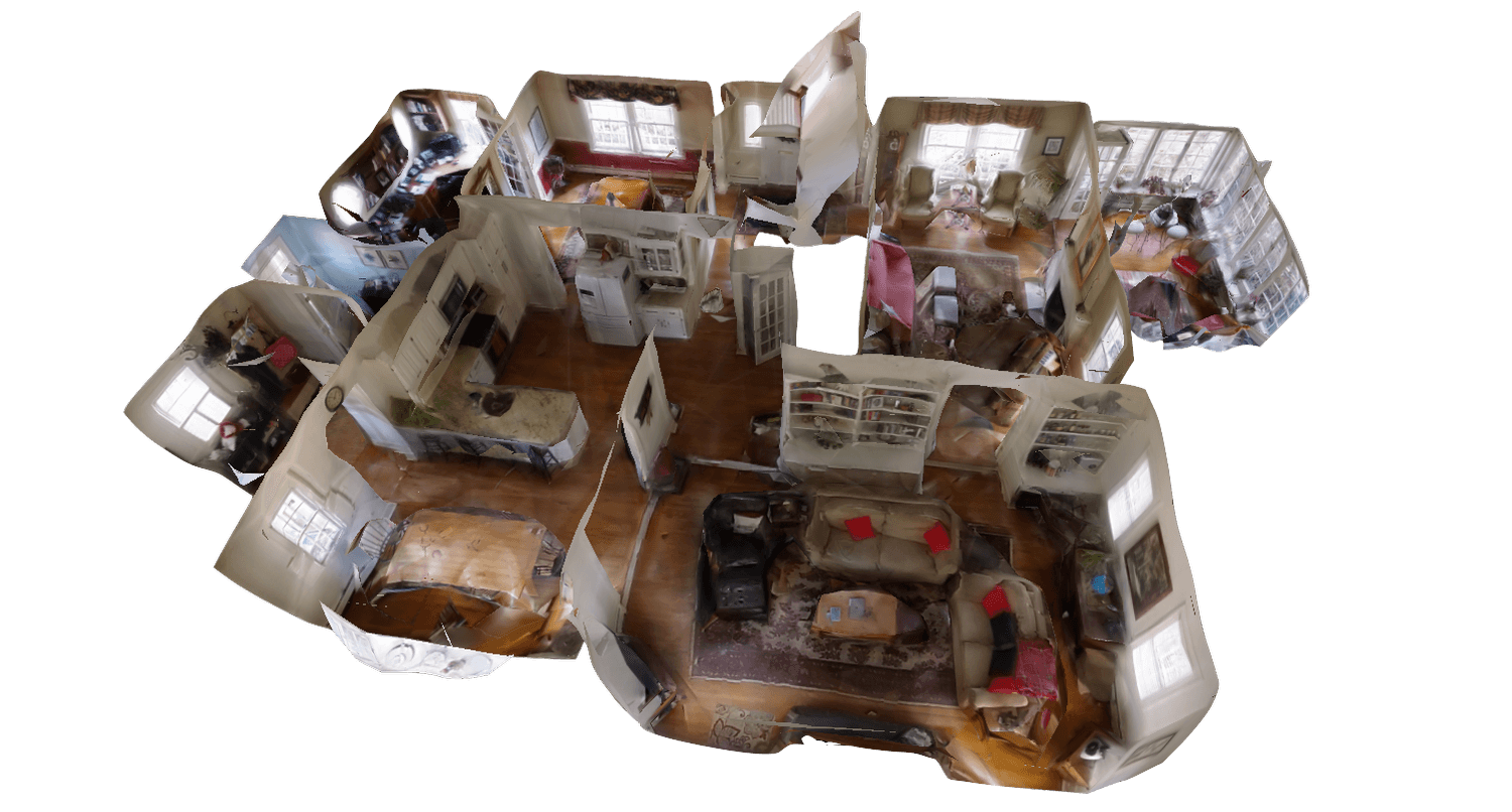
OSV is the 360 video file format the Avata 360 records to its SD card. Photogrammetry is the practice of measuring and modeling a scene from overlapping still photos. Traditional photo workflows need hundreds of planned shots, ground control points and hours of processing. Videogrammetry (building the 3D model from the frames of one continuous video) gives the software hundreds of overlapping frames of every object, which suits a 360 drone that sees in every direction at once.
SkyeBrowse processes video at roughly a minute per minute of footage, and most models are ready 5 to 10 minutes after the upload. In an independent AirBorne Works study from January 2021, SkyeBrowse video models came closest of all tested platforms to the Leica BLK360 laser-scan ground truth, ahead of photo-based Pix4D Mapper and Leica BLK3D (read the whitepaper).
Every model also gets Image Walkthroughs, image icons along the flight path that open the original frames, and with 360 video you can look in every direction. The manual flight and Universal Upload tutorial covers the same upload flow for any drone you fly by hand.
Before You Start
Use the following settings for your Avata 360 to ensure the best 3D model
- Record 6K at 60fps for indoors and 6K 30fps for outdoors.
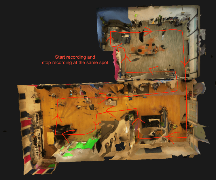
- Fly steadily at 1 mph (indoors) and 5-10mph (outdoors)
- If you are going through doorways or around corners, make sure to slow down.
- Once you are done flying, insert your SD card into your computer
The Easy Way: Upload OSV File into SkyeBrowse
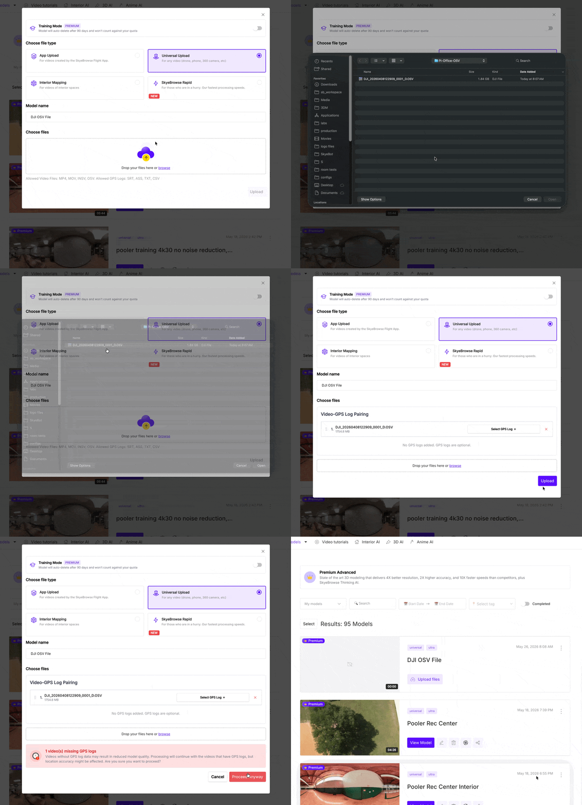
Note: this is quicker, but the quality will be slightly lower.
Initiate Upload: Log in to the SkyeBrowse web platform and click the 'Upload' button.
Select Upload Type: Choose 'Universal Upload' from the options.
Uploading Videos: Select your OSV video file or drag & drop it into the upload box.
The Advanced Way: Export Avata 360 Video on PC/Mac with DJI Studio
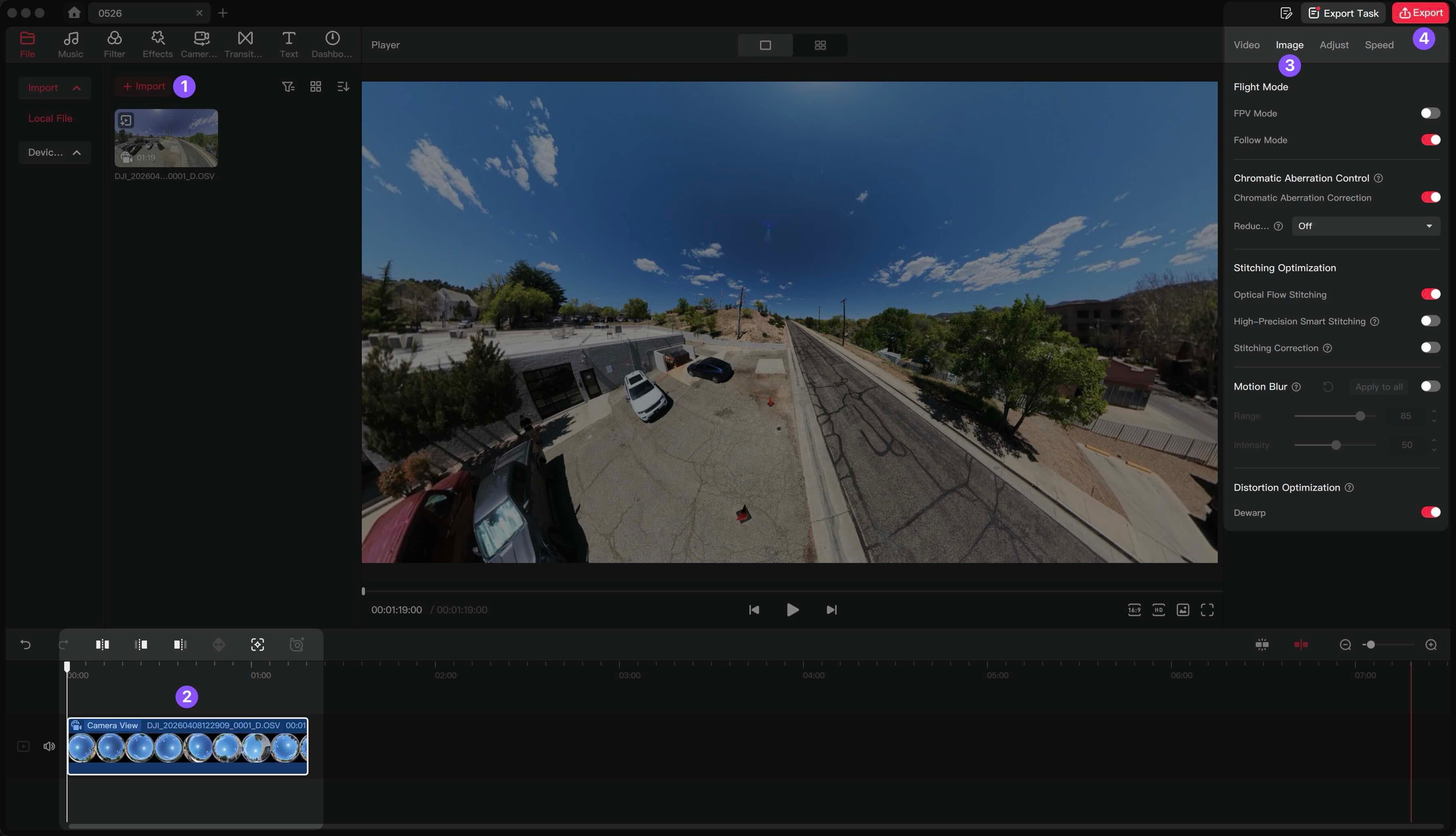 Note: this will result in a higher quality 3D model in SkyeBrowse.
- Open up DJI Studio and import your OSV (DJI Avata 360 video) into DJI Studio
- Drag your video down to the timeline on the bottom.
- In the right panel, select image and make sure the settings are correct (default settings are usually accurate).
- Click Export
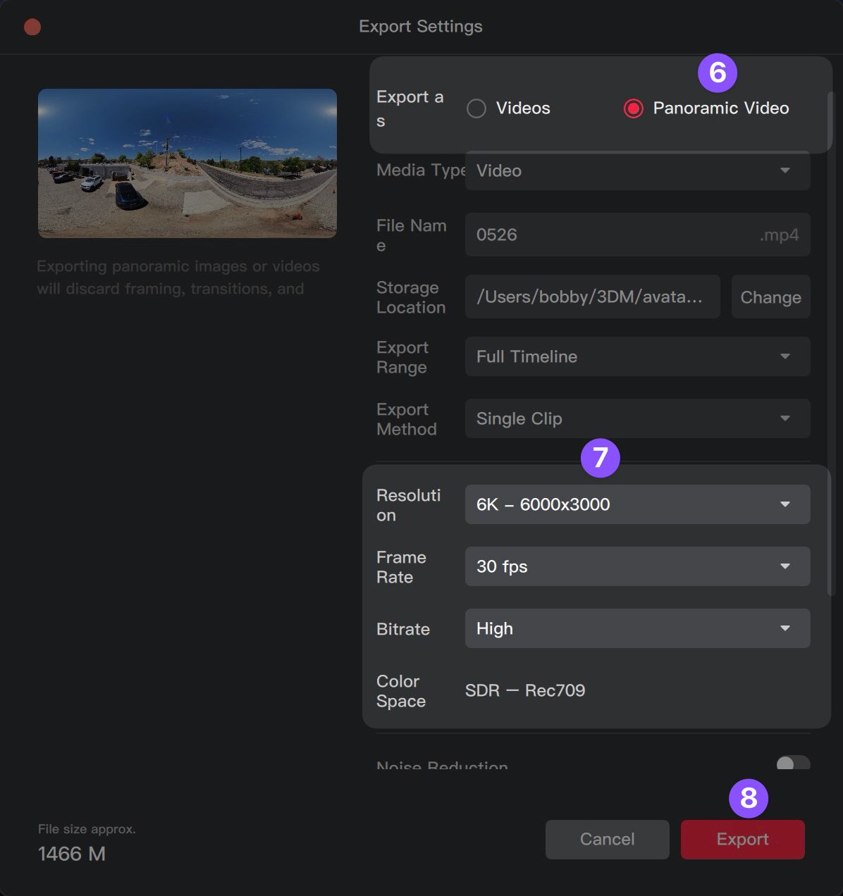
- Ensure that you are exporting as a panoramic video
- Select 6K resolution, 30 fps Frame Rate, High Bitrate
- Click "Export"
How do you upload Avata 360 video to SkyeBrowse?
Log in to SkyeBrowse, click Upload, choose Universal Upload and drop in your .OSV file or DJI Studio export. SkyeBrowse processes the video in the cloud and emails you a link to the finished Avata 360 3D model, usually within minutes.
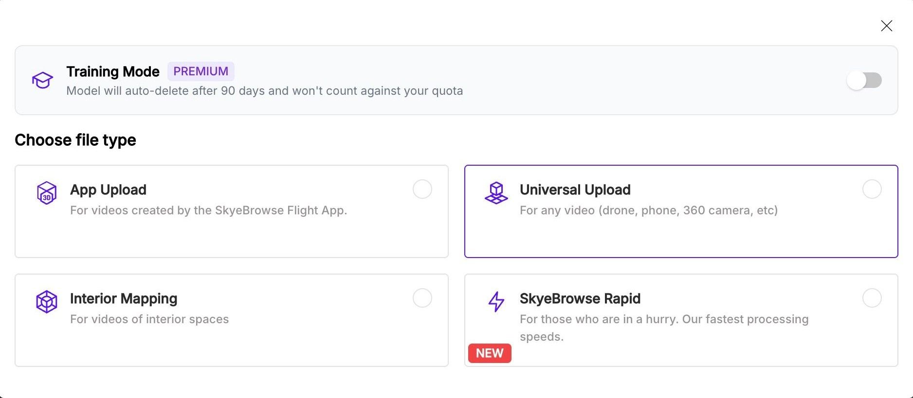
Initiate Upload: Log in to the SkyeBrowse web platform and click the 'Upload' button.
Select Upload Type: Choose 'Universal Upload' from the options.
Uploading Videos: Select your exported video or drag & drop it into the upload box.
Get Avata 360 3D Model: You will receive an email in minutes with the link to your Avata 360 3D model.
By following these steps, you can effectively utilize your Avata 360 for high quality SkyeBrowse 3D modeling. The resulting 3D models can be used for various applications such as real estate showcases, construction planning, tactical applications, and more.
What capture settings work best for an Avata 360 3D model?
Record at 4K or higher, keep the flight slow and smooth, and capture everything in one continuous video. Upload the native .OSV file or a DJI Studio 360 MP4, switch the Interior Mapping toggle on for indoor scans, and set scale with the Scale Tool whenever the model has no GPS file.
| Setting | Interior scan | Exterior scan |
|---|---|---|
| Resolution | 6K (4K or higher recommended; 1080p works with a lower-resolution model) | 6K (4K or higher recommended) |
| Frame rate | 60fps | 30fps |
| Flight speed | About 1 mph, slower through doorways and corners | 5 to 10 mph |
| Flight path | Straight lanes from wall to wall, each overlapping the last | Orbits at two or more altitudes and distances, plus a pass along each facade |
| File to upload | Native .OSV, or DJI Studio 360 MP4 (6K, 30fps, High Bitrate) | Native .OSV, or DJI Studio 360 MP4 (6K, 30fps, High Bitrate) |
| Interior Mapping toggle | On | Off |
| Scale | Scale Tool on a known measurement (a tape measure or doorway width) | Scale Tool when no GPS file is uploaded |
A few habits matter more than any single setting. Keep recording from room to room, and finish by flying back over an area you've already covered. Turn on every light, avoid long runs past glass, mirrors or blank walls, and place a scale reference before you fly.
Flying a single-lens Avata or Avata 2 indoors instead? The DJI Avata interior mapping tutorial covers that setup at 1080p and 60fps with EIS (electronic image stabilization) turned on.
Does the DJI Avata 360 support waypoints, and should you use them for mapping?
Yes, on current firmware. DJI's Avata 360 release notes dated October 20, 2026 (aircraft firmware v01.00.0800) list Waypoint Flight as a new feature. For mapping, waypoints are most useful for repeating the same route on a later visit, because what matters for the 3D model is a slow, smooth path with overlapping passes.
According to the DJI Avata 360 release notes, the same update added DJI RC Pro 2 support and pairs the aircraft firmware with new versions for the remote controllers, goggles and DJI Fly app (v1.21.16). Update the drone, controller and goggles together before you plan a route.
By waypoint or by hand, the mapping pattern is the same:
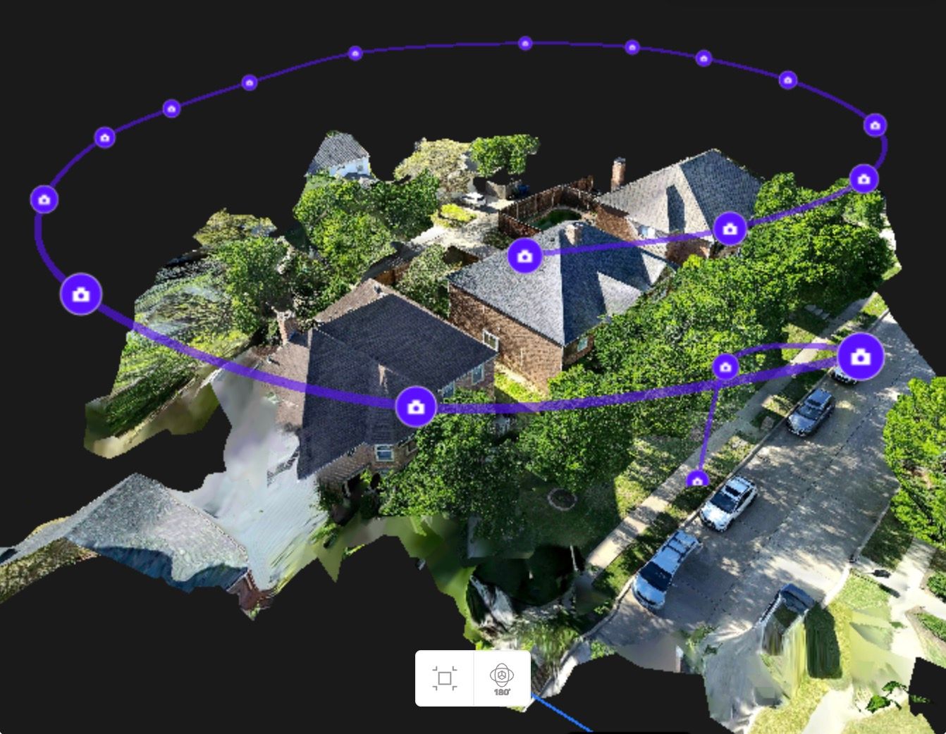
- Small building or single structure: a first orbit high enough to keep the whole building in frame, then a second orbit lower and closer. Every extra orbit should change altitude or distance, since repeating the same circle adds nothing.
- Large site (about an acre or more): a lawnmower grid over the whole area first, each pass overlapping the last, then two or three orbits at different altitudes and a pass along every wall.
- Pace and altitude: hold a consistent altitude on each pass, keep the speed steady at 5 to 10 mph, and avoid sharp yaw or stick inputs.
- Finish: overlap the starting area before you stop recording.
Waypoint routes earn their place on sites you capture repeatedly, like a weekly construction project. Automated flight doesn't change the FAA requirement that the remote pilot or a visual observer keeps the drone within visual line of sight (14 CFR 107.31), which matters on an FPV drone flown with goggles.
How much does it cost to turn Avata 360 video into a 3D model?
Uploading is free. A Freemium account gets unlimited uploads at basic resolution with Distance, Annotate, Draw and Image Walkthroughs. Eligible Freemium organizations can buy their first full Commercial model for $5, with every Pro tool and export and 90-day storage. After that, Commercial models cost $24.99 and Pro models $49.99.
Freemium models stay in a 30-day archive, have no exports, and each upload can be up to 2GB, which also applies to the $5 first model. Check 360 file sizes before uploading on a free account. Commercial and Pro accept up to 3 videos per model at 10GB each and process at 8K with 0.5 inch accuracy.
A Commercial model stays available for 3 months for viewing, measuring and sharing. A Pro model adds 1 year of storage, exports (LAZ, GLB, OBJ, USDZ, GeoTIFF, CAD when available) and AI Floor Plan, which is handy for Avata 360 interior scans. Annual billing takes 20% off both. Full details are on the pricing page.
FAQ
Can I upload the Avata 360 .OSV file directly to SkyeBrowse?
Yes. Universal Upload accepts the native .OSV file straight off the SD card. Exporting a 360 MP4 through DJI Studio first takes a few extra minutes and gives a higher quality 3D model.
Does the SkyeBrowse Flight App work with the DJI Avata 360?
No. The Avata line isn't supported by the SkyeBrowse Flight App. Fly the Avata 360 manually, or on a DJI waypoint route, then upload the video through Universal Upload.
Will my Avata 360 model be georeferenced?
Only if you upload a supported GPS file with the video (.SRT, .ASS, .TXT or .CSV). Without one, SkyeBrowse still builds the model, and you set real-world scale with the Scale Tool using a known measurement.
How long does SkyeBrowse take to process an Avata 360 video?
Processing runs at about one minute per minute of video, and most models are ready 5 to 10 minutes after the upload finishes. You get an email with the link to your model when it's done.
Public safety agencies on an unlimited annual Public Safety & Enterprise plan receive 1 free DJI Avata 360 and 1 free Insta360 X5 camera with the plan.
Big thanks to Pilot Institute for helping us with testing. Check out their free SkyeBrowse course here.
Ready to map your own flight? Upload your first Avata 360 video free, and if your organization is eligible, your first full Commercial model is just $5.