LiDAR and photogrammetry both produce 3D spatial data, but they measure the world in fundamentally different ways. LiDAR fires laser pulses and records the time each pulse takes to return, building a point cloud from millions of distance measurements. Photogrammetry extracts 3D geometry from overlapping photographs by triangulating matching features across multiple images. The choice between them shapes your equipment budget, field workflow, and the type of deliverable your team receives at the end.
For teams evaluating drone photogrammetry alongside LiDAR, the differences go beyond accuracy specs. Sensor cost, vegetation penetration, texture quality, and operator training all factor into which method works in practice.
Key Takeaways
- LiDAR fires laser pulses to build geometry in any lighting condition and can penetrate vegetation canopy; photogrammetry reconstructs 3D from overlapping images and captures photo-realistic color and texture that LiDAR cannot.
- Both methods achieve centimeter-level accuracy under controlled conditions, but LiDAR hardware costs $15,000-$250,000+ while a mapping-capable drone for photogrammetry runs $1,000-$10,000.
- LiDAR requires specialized training for sensor calibration and data registration; a drone photogrammetry flight over the same intersection finishes in 10-15 minutes versus 60-90 minutes for a terrestrial LiDAR scan.
- Choose LiDAR for terrain mapping under dense vegetation, floodplain surveys, or corridor work focused purely on elevation; choose photogrammetry when photo-realistic textures, visual outputs for stakeholders, or budget constraints apply.
- SkyeBrowse's videogrammetry approach processes continuous video at roughly 1:1 speed with Premium Advanced delivering 0.1-inch accuracy — forensic-grade results without the six-figure hardware investment LiDAR demands.
Contents
- How Does LiDAR Capture Work?
- How Does Photogrammetry Capture Work?
- What Are the Accuracy Differences Between LiDAR and Photogrammetry?
- How Do Field Deployment Requirements Compare?
- When Should You Choose LiDAR Over Photogrammetry?
- LiDAR vs Photogrammetry Comparison Table
- Where Does SkyeBrowse Fit?
How Does LiDAR Capture Work?
LiDAR (Light Detection and Ranging) emits thousands of laser pulses per second and records the return time for each pulse to calculate distance. The result is a dense point cloud with precise XYZ coordinates that does not depend on ambient light or surface texture.
Terrestrial scanners capture from fixed tripod positions, airborne sensors mount to aircraft or drones for large-area sweeps, and mobile platforms ride on vehicles or handhelds. Cost varies widely: airborne LiDAR sensors start above $100,000, while handheld SLAM-based units begin around $15,000. The hardware investment is the primary barrier for teams considering LiDAR.
How Does Photogrammetry Capture Work?
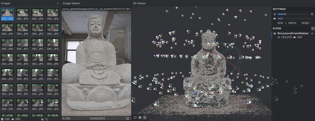
Photogrammetry reconstructs 3D geometry by identifying matching features across overlapping photographs taken from different angles. Software triangulates these features to compute surface coordinates, generating point clouds, meshes, and orthomosaic maps.
Drone photogrammetry has made the method far more accessible. A standard drone captures hundreds of images during a programmed flight, and processing software stitches them into georeferenced 3D models. Hardware is affordable ($1,000-$10,000 for a mapping-capable drone), but traditional processing can take hours or days depending on image count and computing resources. Photogrammetry also produces photo-realistic textures that LiDAR cannot, which matters for courtroom presentations and visual documentation.
What Are the Accuracy Differences Between LiDAR and Photogrammetry?
Both methods achieve centimeter-level accuracy under controlled conditions, but through different measurement paths. LiDAR accuracy depends on sensor quality and GPS/IMU precision. Photogrammetry accuracy depends on image overlap, ground control points, and processing parameters.
Survey-grade airborne LiDAR typically delivers 2-5 cm vertical accuracy. RTK-enabled drone photogrammetry with GCPs can reach 1-3 cm horizontal and vertical accuracy for 3D mapping projects. Without ground control, drone photogrammetry accuracy drops to 10-30 cm, which is still adequate for many operational uses but not for survey-grade deliverables.
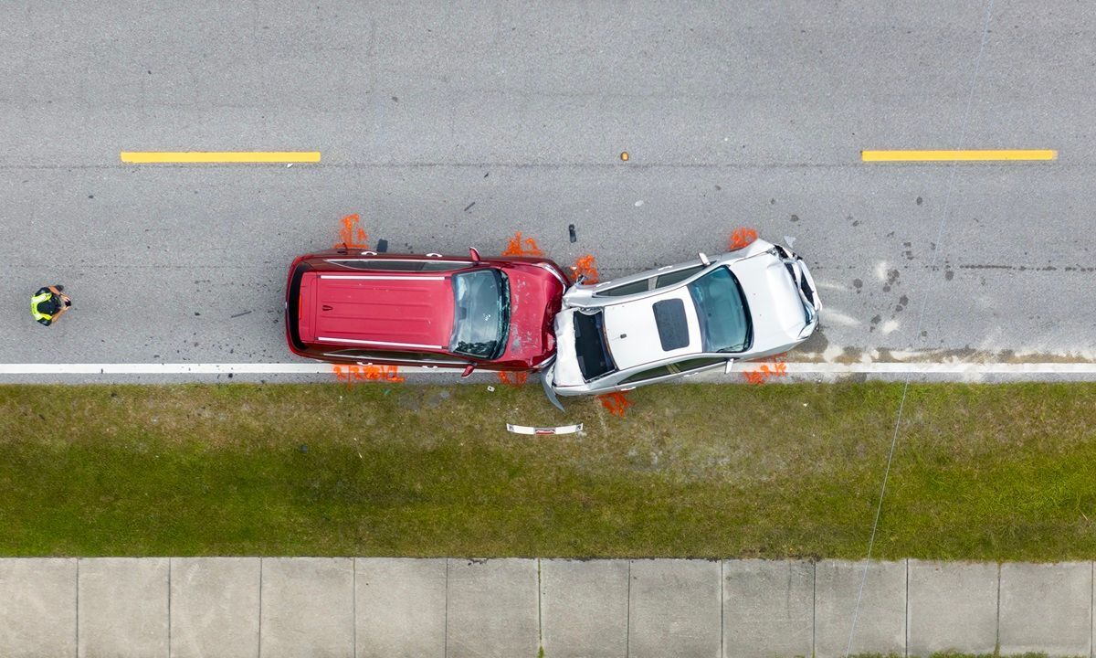
The practical difference shows up in specific scenarios. LiDAR penetrates vegetation canopy and captures ground elevation beneath trees — photogrammetry cannot. Photogrammetry captures color and texture detail that LiDAR misses. For accident reconstruction and crime scene work, the visual fidelity of photogrammetry often matters as much as raw positional accuracy because investigators need to see surface details, not just geometry.
How Do Field Deployment Requirements Compare?
LiDAR requires specialized hardware and trained operators for sensor calibration and data registration. A terrestrial scan of an intersection might need 8-12 stations and 60-90 minutes of setup. Photogrammetry field deployment is simpler — a drone pilot flies a planned orbit while the camera captures automatically.
A drone photogrammetry flight over the same intersection finishes in 10-15 minutes. For teams managing active scenes, that time difference directly impacts road closure duration and officer exposure. The lower hardware barrier also means more team members can capture, and backup equipment is inexpensive.
When Should You Choose LiDAR Over Photogrammetry?
Choose LiDAR when you need to map terrain under dense vegetation, capture geometry in darkness, or deliver raw point cloud density above 100 points per square meter. LiDAR fits best when surface texture is irrelevant — topographic surveys, floodplain mapping, or corridor surveys focused purely on elevation.
Choose photogrammetry when you need photo-realistic textures, color-accurate documentation, or visual outputs for non-technical stakeholders. It is also the practical choice when budget rules out LiDAR hardware or when deliverables must work in both 3D viewers and 2D orthomosaic formats. For most public safety, construction, and inspection teams, drone photogrammetry covers the accuracy requirements at a fraction of the cost.
LiDAR vs Photogrammetry Comparison Table
| LiDAR | Photogrammetry | |
|---|---|---|
| Sensor Type | Active laser ranging | Passive image-based |
| Typical Accuracy | 2-5 cm (airborne), <1 cm (terrestrial) | 1-3 cm (with GCPs), 10-30 cm (without) |
| Vegetation Penetration | Yes — captures ground through canopy | No — sees only visible surfaces |
| Texture/Color | No native color (intensity only) | Full RGB photo-realistic texture |
| Hardware Cost | $15,000-$250,000+ | $1,000-$10,000 (drone + camera) |
| Low-Light Performance | Excellent — does not need ambient light | Poor — needs consistent lighting |
| Processing Time | Minutes to hours (registration) | Hours to days (traditional) |
| Operator Training | High — sensor calibration and registration | Moderate — flight planning and overlap |
Where Does SkyeBrowse Fit?
SkyeBrowse bridges the gap between LiDAR speed and photogrammetry accessibility through videogrammetry — converting continuous video into 3D models without hundreds of photos or a LiDAR sensor. The SkyeBrowse Flight App automates drone capture with a simple orbit, and Universal Upload accepts .MP4/.MOV from any camera. Processing runs at roughly 1:1 (one minute of video produces a model in about one minute), eliminating the multi-hour bottleneck of traditional photogrammetry. Premium Advanced delivers 16K resolution with 0.1-inch accuracy and AI moving object removal — forensic-grade results without the six-figure hardware investment LiDAR demands.
Get a SkyeBrowse Recommendation
If you need photogrammetry-quality textures with processing speed closer to LiDAR, request a demo to see how videogrammetry fits your workflow.