Total stations and drone mapping represent two different eras of spatial measurement. A total station is an electronic theodolite integrated with a distance meter — the operator aims at a target, presses a button, and records a single point with sub-millimeter precision. Drone mapping captures overlapping images or continuous video from the air and reconstructs a complete 3D surface model. One measures individual points with extreme precision; the other captures entire scenes with comprehensive coverage. For teams choosing between these tools, the decision hinges on whether you need a sparse set of highly accurate control points or a dense, measurable 3D model of the full scene.
Key Takeaways
- A total station delivers 1–3 mm accuracy at individual operator-selected points; RTK drones with GCPs achieve 1–3 cm across every visible surface — comprehensive coverage versus pinpoint precision.
- Field time is dramatically different: a total station needs a two-person crew and 60–90 minutes for a complex intersection; drone mapping takes one pilot and under 15 minutes for the same scene.
- Equipment cost favors drones significantly — a professional total station runs $15,000–$50,000, while a capable mapping drone costs $1,000–$10,000 with software from free to approximately $199 per model credit.
- SkyeBrowse Premium Advanced delivers 0.1-inch (2.5 mm) accuracy at 16K resolution and is used by more than 1,200 agencies worldwide, meeting evidentiary standards that total station users expect.
- Many teams now combine both methods: the total station establishes millimeter-accurate ground control points while the drone captures wall-to-wall 3D coverage — the hybrid approach is increasingly standard in forensic engineering and public safety.
Contents
- How Does a Total Station Measure a Scene?
- How Does Drone Mapping Capture a Scene?
- What Are the Accuracy Differences?
- How Do Field Time and Deployment Compare?
- When Should You Use Each Method?
- How Do Total Station and Drone Mapping Costs Compare?
- Where Does SkyeBrowse Fit in Drone Mapping?
- FAQ
How Does a Total Station Measure a Scene?
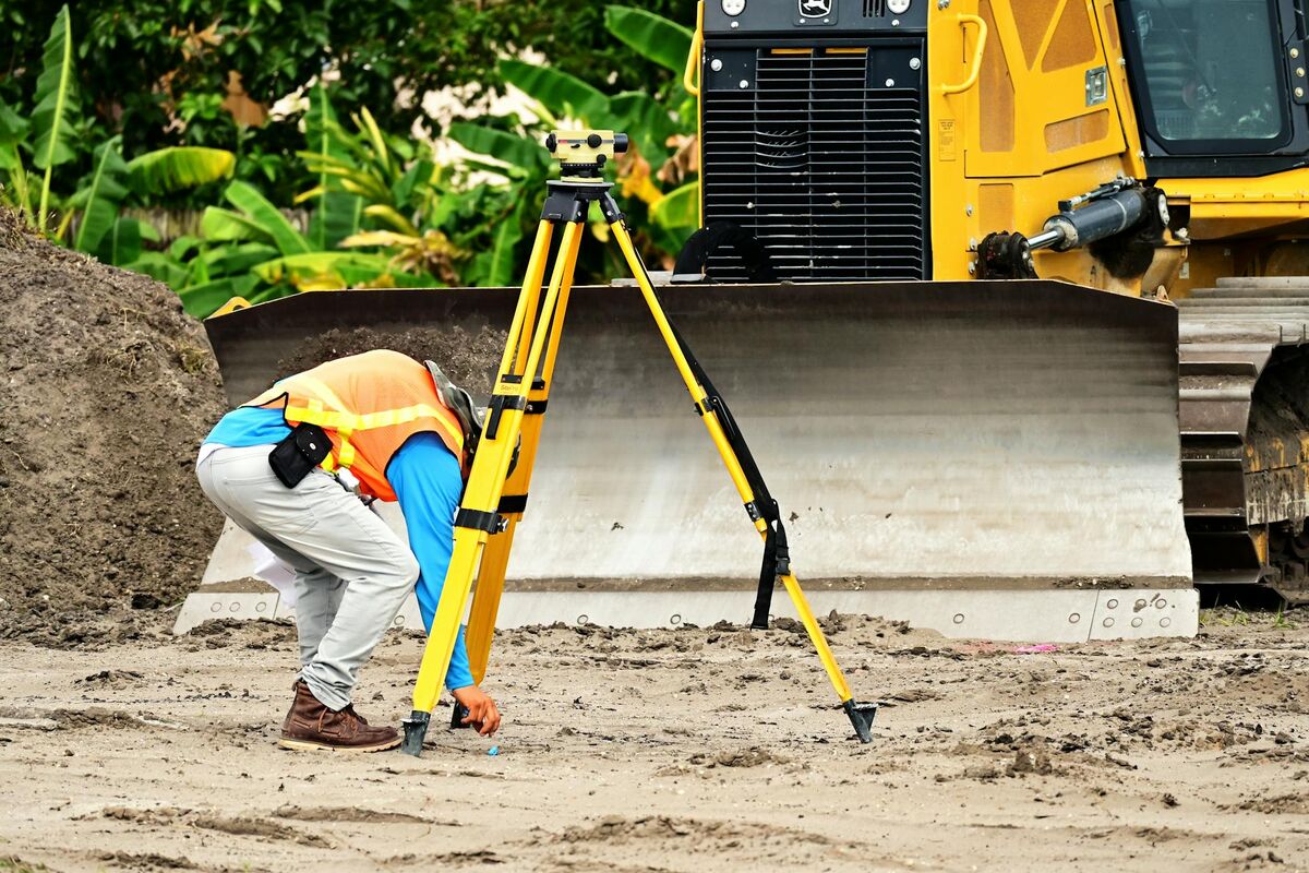
A total station combines an electronic theodolite with an EDM (electronic distance measurement) unit to measure angles and distances to each prism target. The operator sets up over a known control point, levels the instrument, and aims at reflectors placed throughout the scene. Each shot produces a single XYZ coordinate with 1–3 mm precision.
A crash scene typically involves shooting 50–200 points: lane markings, tire marks, vehicle positions, and debris. A two-person crew completes a complex intersection in 60–90 minutes. Data imports into CAD as a 2D diagram — geometrically precise but visually sparse, with no texture, color, or 3D surface between points. If a measurement was missed, the only option is returning to a scene that may no longer exist.
The ASPRS Positional Accuracy Standards recognize total station surveys as a reference-accuracy benchmark for horizontal and vertical control, which is why they remain the preferred method for establishing ground control points used in drone mapping workflows.
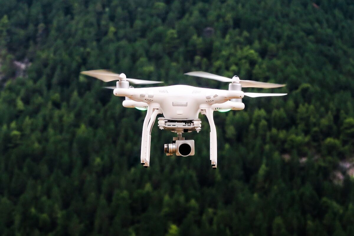
How Does Drone Mapping Capture a Scene?
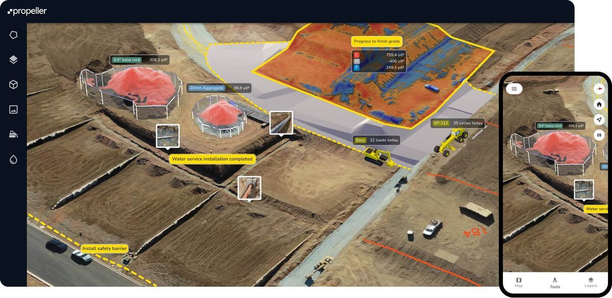
Drone mapping captures the entire visible surface from the air. The drone flies an orbit or grid pattern while recording overlapping images or continuous video, and processing software reconstructs a 3D model, point cloud, and orthomosaic. Every visible surface is documented simultaneously — not just operator-selected points.
A single operator launches, captures, and lands in 10–15 minutes for a typical intersection. Measurements not anticipated during capture can still be extracted from the model afterward — eliminating the "missed measurement" problem of point-based methods. For drone surveying and mapping applications, the textured 3D output is also more intuitive for non-technical stakeholders than a CAD drawing of scattered points. Our aerial photogrammetry guide explains the underlying capture science in detail.
Videogrammetry — a method that uses continuous video frames instead of individual photos — extends this further by enabling a single automated orbit flight to produce a complete 3D model. FAA Part 107 certification is required for commercial drone operations, and most public safety and survey agencies maintain Part 107-certified pilots on staff.
What Are the Accuracy Differences?
Total stations deliver the highest point accuracy of any field survey instrument — 1–3 millimeters at typical working distances. Drone mapping accuracy depends on workflow: RTK-enabled drones with ground control achieve 1–3 cm, standard GPS-tagged captures reach 10–30 cm, and premium videogrammetry tiers reach 0.1-inch (2.5 mm) accuracy. No drone method matches total station precision at individual points, but drone mapping covers the entire scene rather than a set of operator-selected locations.
The core tradeoff is coverage versus precision. A total station gives millimeter accuracy at measured points only. A drone gives centimeter accuracy across every visible surface. According to the National Geodetic Survey, terrestrial survey methods — including laser scanners like the Leica BLK360 — remain the standard for geodetic control, while aerial photogrammetry and drone-based methods are accepted for most documentation, as-built, and forensic applications. For most documentation scenarios, comprehensive coverage provides more actionable information than pinpoint accuracy at a limited set of points.

How Do Field Time and Deployment Compare?
Field time is where the comparison becomes most dramatic. A total station survey requires a two-person crew, 10–15 minutes of setup, and 60–90 minutes of measurement at a complex intersection. Drone mapping requires one Part 107 pilot, 2–3 minutes of setup, and 5–15 minutes of capture — the same scene finishes in under 15 minutes total.
Shorter road closures, lower overtime costs, and reduced officer exposure all favor drone mapping for time-critical scenes. A total station kit weighs 30–40 pounds and requires a tripod, prism poles, and a second operator. A mapping drone fits in a backpack — a meaningful advantage for agencies that need documentation capability on every shift without dedicated survey crews.
When Should You Use Each Method?
Use a total station when sub-millimeter precision at specific control points is required, for boundary surveys, construction machine control layout, or when regulations mandate total station measurements. Use drone mapping when comprehensive scene documentation, single-operator deployment, or visual 3D deliverables are the priority. Many teams now use both: the total station establishes ground control, the drone captures the full scene.
Accident reconstruction, construction progress monitoring, roof inspection, and scene preservation all favor drone mapping. The hybrid approach — total station for control, drone for coverage — combines the best of both: millimeter-accurate reference points anchoring wall-to-wall 3D coverage. This workflow is increasingly standard among forensic engineering teams and public safety agencies that need both evidentiary precision and comprehensive documentation.
How Do Total Station and Drone Mapping Costs Compare?
A professional total station costs $15,000–$50,000 in equipment alone and requires two trained operators for field work. A mapping drone capable of producing survey-grade outputs costs $1,000–$10,000, requires one pilot, and software costs range from free open-source tools to $99–$199 per model credit for cloud-based platforms. For agencies or firms running frequent documentation jobs, drone mapping delivers lower per-project cost and significantly faster turnaround.
| Total Station | Drone Mapping | |
|---|---|---|
| What It Measures | Individual points (operator-selected) | Entire visible surface |
| Point Accuracy | 1–3 mm | 1–3 cm (with GCPs), 2–6 in (standard) |
| Coverage | Sparse — only measured points | Comprehensive — every visible surface |
| Crew Required | 2 people minimum | 1 pilot |
| Typical Capture Time | 60–90 min (intersection) | 10–15 min (same scene) |
| Output Type | XYZ coordinate list for CAD | 3D model, point cloud, orthomosaic |
| Post-Capture Measurements | No — only what was shot | Yes — measure anything visible in model |
| Equipment Cost | $15,000–$50,000 | $1,000–$10,000 |

Where Does SkyeBrowse Fit in Drone Mapping?
SkyeBrowse is a cloud-based videogrammetry platform that converts drone video into 3D models without desktop hardware or complex flight planning. The SkyeBrowse Flight App programs an automated orbit in seconds, the .MP4 uploads to app.skyebrowse.com for cloud processing, and a 10-minute capture returns a finished 3D model in about 10 minutes. Premium Advanced tier delivers 0.1-inch (16K) accuracy — satisfying measurement standards that total station users expect.
For teams transitioning from total stations, SkyeBrowse eliminates the learning curve of grid planning and desktop photogrammetry software. Universal Upload accepts video from handheld cameras for interior documentation, extending the same workflow to spaces a drone cannot enter. More than 1,200 agencies worldwide — including public safety, construction, and forensic engineering teams — use SkyeBrowse to supplement or replace point-based survey workflows with comprehensive 3D scene capture. See our drone surveying guide for a full breakdown of flight planning, accuracy tiers, and deliverable formats across drone survey workflows.
FAQ
Can drone mapping replace a total station entirely?
For most documentation use cases — accident reconstruction, construction progress, roof inspection, and scene preservation — drone mapping now replaces the total station as the primary tool. Total stations remain essential for boundary surveys, machine control layout, and any application requiring sub-millimeter point accuracy at specific control locations.
How accurate is drone mapping compared to a total station?
A total station achieves 1–3 mm accuracy at individual measured points. RTK-equipped drones with ground control points achieve 1–3 cm across the full scene. SkyeBrowse Premium Advanced delivers 0.1-inch (2.5 mm) accuracy at 16K resolution. For comprehensive scene coverage, drone mapping accuracy is sufficient for most legal and engineering documentation requirements.
What is videogrammetry?
Videogrammetry is a 3D reconstruction method that uses continuous video frames instead of individual photos. A drone records overlapping video footage of a scene; cloud processing software analyzes frame sequences to build a point cloud, 3D mesh, and orthomosaic. SkyeBrowse uses videogrammetry to deliver finished 3D models from a 10-minute drone flight — no grid pattern or photo overlap calculations required.