A drone digital twin is only useful if it is current enough to influence a decision. Teams often capture a site, send the data into a heavy reality-capture workflow, and receive a model too late to help with schedule recovery, owner updates, or field coordination. A useful drone digital twin workflow has to compress the time between capture and review.

Key Takeaways
- A drone digital twin is only useful when it is current enough to influence a decision — a single model capture is a historical artifact, not a true operational twin.
- Most digital twin programs stall because the capture-to-model pipeline is too slow and specialist-driven for routine use; useful twins require refresh frequency the whole team can sustain.
- Videogrammetry compresses the digital twin update cycle: short drone video uploads to SkyeBrowse and returns a shareable model fast enough for same-day comparison against prior progress records.
- SkyeBrowse exports LAZ, GLB, and GeoTIFF files compatible with downstream BIM, GIS, and owner-reporting workflows without requiring a full photogrammetry workstation.
- The strongest drone digital twin programs make reality capture routine — not a special event — which is the operational gap SkyeBrowse is built to close.
Contents
- What is a drone digital twin?
- Why do many digital twin programs stall out?
- How do drones feed a practical digital twin workflow?
- Where does SkyeBrowse fit in a digital twin stack?
- What makes a drone digital twin operationally useful?
- FAQ
What is a drone digital twin?
A drone digital twin is a current digital representation of a physical asset or job site that is refreshed with recurring aerial capture rather than treated as a one-time model. The drone supplies the repeat current-condition data that keeps the twin useful instead of static.
In practical construction terms, the drone is not the twin. The drone is the repeat capture mechanism. Autodesk's guide to digital twins describes the twin as a data-rich representation of the real asset, while buildingSMART's openBIM definition emphasizes usable information continuity across disciplines. The drone provides current exterior conditions, grade change, installed work, and site logistics visibility that can be layered against design intent, schedule expectations, and downstream facility information. That only works when capture is frequent enough and the model is accessible enough that the field actually uses it. A digital twin is a navigable 3D replica of a physical site — see our complete guide to digital twin technology for background. For a walkthrough of how drones capture the raw 3D data that feeds into digital twin workflows, see our drone 3D mapping guide.
Why do many digital twin programs stall out?
Many digital twin programs stall out because the data pipeline is too slow, too expensive, or too specialist-driven for recurring use. A delayed model may look impressive, but it does not function as a true operational twin.
The usual failure mode looks like this: capture requires a specialist crew, processing requires a workstation or a complex cloud pipeline, and only a small technical group can open the output. By the time the model is ready, the site has changed again. Autodesk's digital project delivery guidance points to the same operational problem: when site information moves too slowly, downstream coordination and owner decisions slow down too. The digital twin in construction guide covers how construction teams structure recurring capture schedules to avoid this failure mode.
To stay alive operationally, the workflow has to be short enough that the superintendent, VDC lead, or owner representative can request a refresh and get value from it the same day.
How do drones feed a practical digital twin workflow?
Drones feed a practical digital twin workflow by making repeat exterior capture cheap, predictable, and fast enough to sustain. Short recurring flights create a time series of current conditions instead of a static archive.
Videogrammetry — the process of building spatial models from video rather than structured photo sets — is especially strong here because it removes much of the overhead that slows repeat programs down. Instead of planning a full photogrammetry mission every time, a team can capture short video, upload it, and receive a usable model fast enough to compare against the last revision. The videogrammetry pipeline matches video duration: ten minutes of flight footage produces a georeferenced 3D model in ten minutes flat. That is a better fit for digital-twin cadence than a workflow built around occasional large processing jobs.
That is also why drone twins overlap with construction progress monitoring and drone as-built documentation: both depend on a current-condition model rather than a one-time capture event.

| Digital twin need | What drone capture adds |
|---|---|
| Current site condition | Fast exterior refresh without a long survey cycle |
| Stakeholder visibility | Shareable 3D model instead of static photos |
| Schedule verification | Frequent capture points for progress comparison |
| Handoff record | Time-stamped spatial archive of installed work |
| Lifecycle context | A model that can inform later operations and maintenance |
Where does SkyeBrowse fit in a digital twin stack?
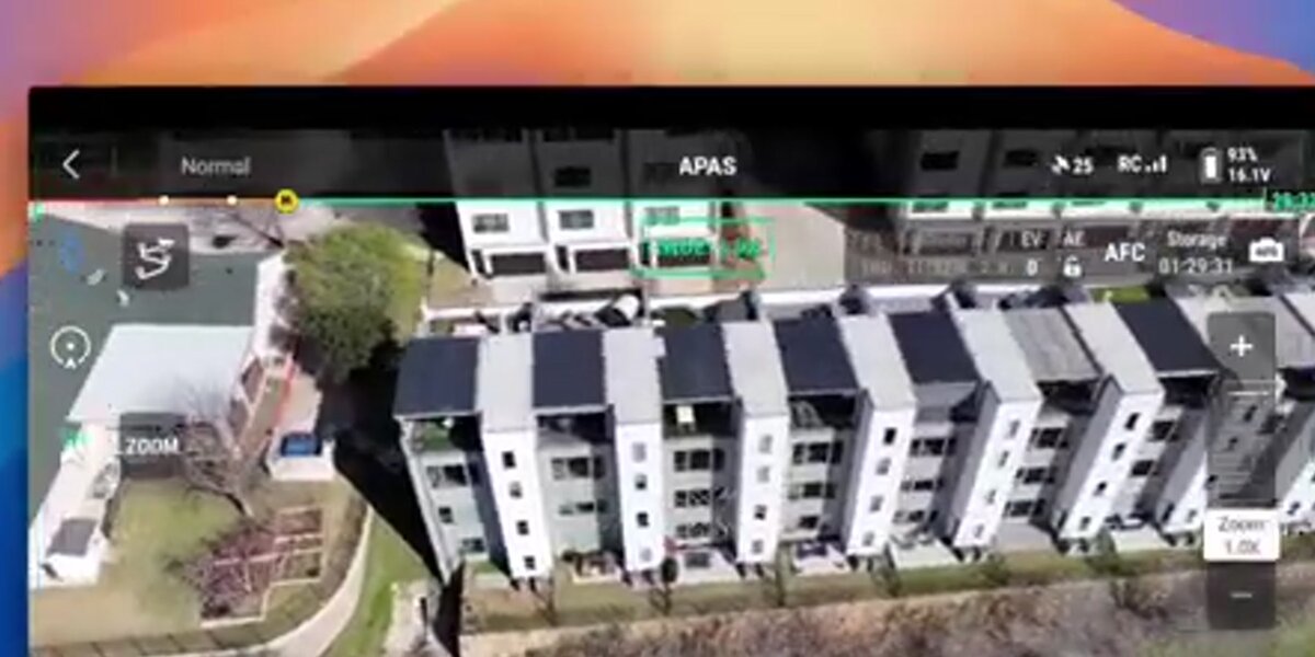
SkyeBrowse fits at the refresh layer of the digital twin stack. It turns recurring field capture into accessible spatial output without forcing the team through a slow reconstruction loop every time.
That matters because digital twins fail when reality capture becomes a special event. With SkyeBrowse, a team can use the SkyeBrowse Flight App or Universal Upload, process short video, and export LAZ, GLB, or GeoTIFF outputs for downstream BIM, GIS, or owner-reporting workflows. Models persist on AWS GovCloud with 5-year retention on Premium tiers, and export to LAZ, GLB, and GeoTIFF for use in Civil 3D, Revit, Trimble Business Center, and standard GIS tools. The result is not a full BIM authoring environment. It is the fast current-condition layer that keeps the rest of the digital twin honest.
Accuracy tier selection in this workflow is directly tied to how the drone is flown. Flights at lower altitude (below 100 feet AGL) with slower airspeed and tighter orbit overlap feed the processing engine more detail per frame, enabling Premium and Premium Advanced outputs at 0.25-inch and 0.1-inch respectively. Faster passes at higher altitude — appropriate for rapid situational awareness — map to the Lite tier (2–6 inch accuracy), which is sufficient for progress comparison but not for as-built sign-off. Matching flight parameters to the required accuracy tier before takeoff avoids reflies.
For teams focused more narrowly on project review than lifecycle twin strategy, the related BIM coordination drone workflow is the closest companion use case. For building owners creating a twin of a specific structure, the digital twin building guide walks through the exterior and interior capture workflow.
What makes a drone digital twin operationally useful?
A drone digital twin becomes operationally useful when it is current, shareable, and tied to actual project decisions. If it helps the team verify work, communicate delay, or measure change, it is doing its job.
That is why processing speed matters so much. The fastest twin update is usually the most valuable twin update. Teams are trying to answer immediate questions: What changed since last week? Does installed work match expectation? What does the owner need to see today? Fast videogrammetry makes those questions answerable on a routine cadence.
FAQ
Is a drone model the same thing as a digital twin?
No. A single drone model is a capture artifact. A digital twin is an ongoing, refreshed representation of the real asset that supports decisions over time.
Why are drones useful for digital twins?
Drones make repeat exterior capture fast, inexpensive, and scalable, which is essential when the twin needs to stay current during active construction or ongoing operations.
Where does SkyeBrowse fit?
SkyeBrowse fits at the rapid current-condition layer, turning drone video into shareable models fast enough for recurring use.
The strongest drone digital twin programs are not the ones with the most complex dashboards. They are the ones that make reality capture routine. That is the operational gap SkyeBrowse is built to close.