On September 10, 2025, Charlie Kirk was fatally shot while speaking at an outdoor event at Utah Valley University in Orem, Utah, according to the FBI's press releases on the case. Reporting indicated the shot came from an elevated position on a building near the crowd. An event like that raises one question for every protective team running advance work: sightline analysis, the practice of identifying every position with a clear view of a stage or principal before an event happens, not after.
Key Takeaways
- SkyeBrowse's Line of Sight tool places up to two observer points on a textured 3D model, coloring every visible area green and every blocked area red, so a team can check an elevated position from a desk instead of a rooftop climb.
- The Utah Valley University campus model was built from a single continuous drone flight, with SkyeBrowse processing the footage at roughly a 1:1 ratio, about one minute per minute of video.
- On Public Safety & Enterprise, the resulting model reaches survey-grade, court-admissible accuracy without ground control points or a scanning specialist on site.
- A two-observer comparison confirms whether an overwatch or counter-sniper post actually covers a position of concern, instead of leaving that judgment to assumption.
- Line of Sight and Sun and Shadow are included on Pro and Public Safety & Enterprise at app.skyebrowse.com.
Contents
- Why Is Sightline Analysis the Hardest Part of Event Advance Work?
- How Was the Utah Valley University Campus Captured as a 3D Model?
- How Does the Line of Sight Tool Check Every Elevated Position?
- What Does This Case Study Teach Protective Security Teams?
- How Can Protective Teams Run Their Own Sightline Survey?
- FAQ
This case study is an after-action protective-security analysis prepared for training purposes. It is not a forensic finding, and it does not assess the ongoing investigation into the shooting. The aim is defensive: to document how sightline analysis supports advance work for open-air events. With the help of SkyeBrowse partners at Public Safety UAS and the Utah Valley University Police Department, a SkyeBrowse model of the campus was built so the sightlines could be studied and the lessons recorded.
Why Is Sightline Analysis the Hardest Part of Event Advance Work?
Sightline analysis is the process of identifying every position around a venue with a clear view of the stage or principal, ranking those positions by threat, and assigning coverage, lockdown, or observation before an event starts. Elevated positions, rooftops, parking structures, upper-floor windows, and stair landings, are the hardest to clear because a team cannot stand where a threat would stand and look back at the stage from the ground.
The traditional method is to climb to each suspected position and judge the view by eye. That method is slow, it leaves angles unchecked, and any blind spot that goes unrecorded becomes a gap on the day of the event. CISA's Venue Guide for Security Enhancements recommends venue operators evaluate physical security measures against the venue's specific layout and risk factors, the same position-by-position judgment a rooftop walk is trying to make one climb at a time.
How Was the Utah Valley University Campus Captured as a 3D Model?
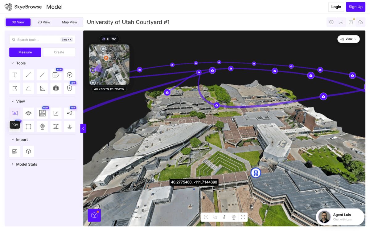
Public Safety UAS flew the Utah Valley University campus, and the footage was processed into a SkyeBrowse model together with the Utah Valley University Police Department. The capture was a single continuous video, and SkyeBrowse's cloud pipeline turned it into a measurable, walkable 3D model within minutes.
SkyeBrowse uses videogrammetry, a process that builds 3D models from ordinary video instead of the thousands of overlapping still photographs traditional photogrammetry requires. The input for this capture was one drone flight, not a specialist with a tripod-mounted scanner, and no ground control points were needed to tie the model to real-world measurements. The cloud processes footage in roughly one minute per minute of video, and on Public Safety & Enterprise, the result is survey grade and court-admissible. Within minutes of the flight, the team had a measurable, walkable model of the plaza, the surrounding buildings, and every roofline.
How Does the Line of Sight Tool Check Every Elevated Position?
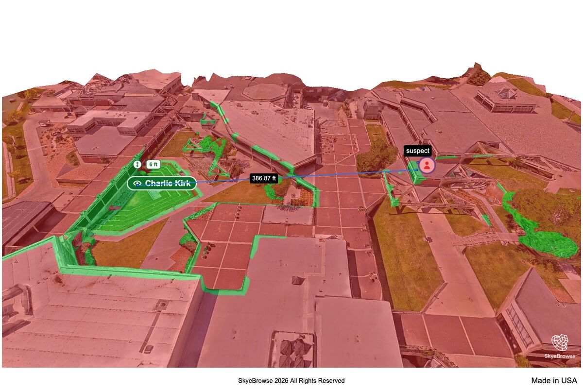
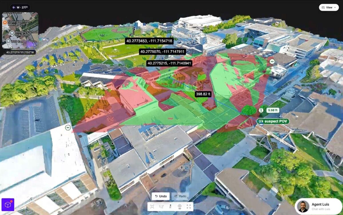
Line of Sight is a SkyeBrowse viewer tool that places an observer point anywhere on the textured 3D model and aims it at a target, such as a stage or podium. Everything the observer can see turns green, and everything blocked by a wall, a parapet, a rooftop air unit, or a tree turns red, giving the team a direct visual answer instead of a guess.
Applied to advance work, the method is straightforward:
- Place the observers. Put one on each elevated position of concern and aim it at the podium.
- Read the green. A podium inside a green zone has a clear line of sight from that position, so it must be covered, occupied, or screened.
- Read the red. The structures that block the stage are existing cover, and they show where a principal is safest and how to route movement.
- Add the overwatch. A second observer enables a two-way comparison that shows what both points see at once, which confirms whether a counter-sniper post actually covers the position.
Each observer can be named and saved in the object tree, so the sightline survey becomes a documented deliverable rather than one team member's recollection of a rooftop walk.
What Does This Case Study Teach Protective Security Teams?
The central lesson is that elevated sightlines are knowable in advance. A rooftop either has a clear view of the stage or it does not, and that geometry does not change between the advance walk and the event. What fails is usually the process, not the physics: the position no one climbed, the angle no one recorded, or the blind spot held in a single person's memory.
Reality capture paired with Line of Sight addresses each of those failure points directly:
- Coverage becomes complete. Placing observers on a model is faster than climbing, so every elevated position gets evaluated rather than sampled.
- The survey is documented. Named observers, the green-and-red overlay, and the measurements produce a record that can be handed to the next shift and reused when the venue is worked again.
- Overwatch is verified. The two-way comparison confirms that observation posts cover the positions of concern instead of leaving it to assumption.
- The whole venue is covered quickly. Parking structures, adjacent rooftops, tree lines, and upper floors can all be evaluated in a single model in an afternoon.
This mirrors the broader guidance from agencies like the Utah Department of Public Safety, which has stressed coordinated, documented planning across agencies for large public events.
How Can Protective Teams Run Their Own Sightline Survey?
Teams that run advance work for events, dignitary visits, or large gatherings can build the same survey on their own venues. The recommended practice is to capture the venue and its surrounding structures in a single flight, process the model, and run Line of Sight on every elevated position during advance planning rather than after an incident.
The capture uses standard equipment: any DJI or Autel drone, or in tighter urban settings, a phone walked around a building's perimeter. SkyeBrowse's Universal Upload accepts .MP4 and .MOV video directly, so a department needs no new hardware to start. Once the model is processed, the team places, names, and saves an observer on every rooftop, parking structure, and upper-floor window in the plan, then hands off that sightline map to the next shift or the next event at the same venue.
FAQ
What is the Line of Sight tool in SkyeBrowse?
Line of Sight is a SkyeBrowse viewer tool that places up to two observer points on a textured 3D model and colors every area that observer can see green, and every blocked or hidden area red. A second observer adds a two-way comparison showing what both points can see at the same time. Observer location, viewing direction, range, and field of view are all adjustable, and each observer can be named and renamed from the object tree.
How accurate does a model need to be for sightline analysis?
SkyeBrowse Commercial and Pro models reach 0.5 inch measurement accuracy at 8K resolution, and Public Safety & Enterprise reaches 0.1 inch at 16K resolution with AI moving-object removal. That level of detail resolves parapets, rooftop units, and window ledges precisely enough to support a defensible sightline survey, and Public Safety & Enterprise output is built to hold up as court-admissible evidence if it is ever needed for that purpose.
How long does it take to build a sightline model of a venue?
SkyeBrowse processes footage at roughly a 1:1 ratio, about one minute of processing per minute of video, from a single continuous drone or phone flight with no ground control points or scanning specialist required. A team can capture a venue and its surrounding rooflines in one flight and run Line of Sight on every position of concern that same afternoon, at app.skyebrowse.com.
Try SkyeBrowse at your agency. Public safety and government agencies can apply for the Pilot Program, a free trial of about two weeks with full Public Safety & Enterprise access. To plan a purchase, request a quote.